
Modern oceans are crowded transportation corridors. Cargo ships, tankers, ferries, fishing vessels, cruise ships, offshore support vessels, tugboats, and recreational craft may all operate in the same waters—sometimes in darkness, fog, heavy rain, or congested ports. In these conditions, knowing who is nearby, where they are heading, and how fast they are moving can be crucial for preventing accidents.
One of the most important technologies supporting this awareness is the Automatic Identification System (AIS). 🚢📡
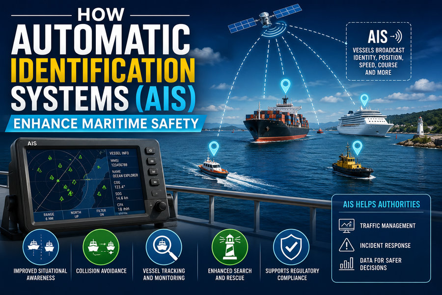
AIS allows appropriately equipped vessels to automatically exchange identification, position, speed, course, and other navigational information over marine VHF radio frequencies. The data can be received by nearby ships, coastal stations, vessel traffic services, and—in many situations—satellites.
AIS does not steer ships or replace navigators. Instead, it provides an additional layer of situational awareness that can help bridge teams identify vessels, assess collision risks, coordinate movements, and respond more effectively during emergencies.
📡 What Is AIS?
The Automatic Identification System is a digital maritime communication system designed primarily to improve vessel identification and navigational safety.
An AIS-equipped vessel periodically transmits information about itself using VHF radio.
Other AIS receivers within range can display this information on equipment such as:
- Electronic chart systems 🗺️
- Dedicated AIS displays
- Radar-integrated navigation systems
- Vessel Traffic Service screens
- Shore-based monitoring centers
Instead of seeing only an unidentified radar target, a navigator may be able to see the vessel’s name, identity, speed, course, and other information.
That additional context can be extremely valuable in busy waterways.
🛰️ What Information Does AIS Transmit?
AIS messages can contain several categories of information.
🚢 Static Information
Static information changes relatively rarely.
It can include:
- Vessel name
- Maritime Mobile Service Identity (MMSI)
- IMO ship identification number, where applicable
- Call sign
- Ship type
- Vessel dimensions
This allows other users to identify the ship rather than simply observing an anonymous target.
🧭 Dynamic Information
Dynamic information changes continuously as the vessel moves.
Typical examples include:
- Latitude and longitude
- Speed over ground
- Course over ground
- Heading
- Rate of turn
- Navigational status
Position and movement information is generally derived from onboard navigation sensors such as satellite positioning equipment.
Dynamic AIS data is transmitted repeatedly, with reporting behavior influenced by factors such as vessel speed, movement, and equipment class.
📋 Voyage-Related Information
For certain AIS installations, additional information may include:
- Destination
- Estimated time of arrival
- Draught
- Navigational status
Some of these fields are entered manually by the ship’s crew.
Because manually entered information can be outdated or incorrect, navigators should not treat every AIS field as automatically verified.
⚙️ How Does AIS Actually Work?
AIS communicates primarily through dedicated channels in the marine VHF radio band.
Ships equipped with AIS transponders both transmit their own information and receive messages from other stations.
A major engineering challenge is allowing many vessels to communicate simultaneously without constantly interfering with one another.
AIS addresses this through carefully organized time-division communication techniques.
The radio channel is divided into small time slots. AIS units coordinate transmission timing so that many vessels can share the same frequencies efficiently.
Class A AIS installations, commonly used aboard larger commercial ships, employ sophisticated automated channel-access techniques such as self-organizing time division multiple access.
The result is a continuously updated digital picture of nearby traffic. 📡🚢🚢
🗺️ 1. AIS Improves Situational Awareness
One of AIS’s greatest safety benefits is improved situational awareness.
Imagine a ship navigating a busy harbor at night.
Radar may reveal numerous targets, but the bridge team may initially have limited information about each one.
AIS can potentially associate vessels with details such as:
Name: Ocean Trader
Speed: 11 knots
Course: 245°
Destination: Port terminal
Ship type: Cargo vessel
This helps navigators build a clearer understanding of surrounding traffic.
Instead of merely asking:
“What is that target?”
they may be able to determine:
“That is a cargo ship approaching the channel from the east.”
Such identification can make communication and decision-making more efficient.
⚠️ 2. AIS Helps Assess Collision Risk
Collision avoidance is one of the most important applications of AIS.
Navigation systems can use AIS position and movement information to estimate whether two vessels are approaching dangerously close to each other.
Two particularly important calculations are:
📍 CPA — Closest Point of Approach
CPA estimates how close another vessel will come if both vessels continue on their current courses and speeds.
A very small CPA may indicate potential danger.
⏱️ TCPA — Time to Closest Point of Approach
TCPA estimates how long it will take before that closest approach occurs.
For example:
CPA: 0.2 nautical miles
TCPA: 8 minutes
could indicate that action may need to be considered promptly.
Navigation equipment can present alarms or warnings when selected collision-risk thresholds are exceeded.
However, AIS is only one source of information. Mariners must still apply the International Regulations for Preventing Collisions at Sea (COLREGs) and use proper navigational judgment.
📞 3. AIS Makes Ship-to-Ship Communication Easier
Before AIS, a navigator seeing an unknown vessel might have difficulty determining exactly which ship to contact by radio.
In crowded waters, a call such as:
“Ship off my starboard bow…”
could potentially be ambiguous.
AIS can provide the target vessel’s identity.
The bridge team can then make a more specific VHF call using the ship’s name or other identifying information.
This can improve communication when vessels need to clarify intentions.
However, radio conversations themselves must be handled carefully. Collision avoidance should not depend solely on informal VHF agreements when the navigational situation requires action under established collision regulations.
🌫️ 4. AIS Is Valuable in Reduced Visibility
Fog, rain, darkness, and snow can significantly reduce visual awareness at sea.
AIS continues to exchange radio-based information under many conditions where visual identification is impossible. 🌫️📡
A vessel hidden in fog may still appear as an AIS target on an electronic navigation display.
This makes AIS especially valuable when combined with:
- Radar
- ARPA
- Electronic charts
- Visual lookout
- Sound signals
- Navigation lights
The key word is combined.
AIS should complement—not replace—traditional navigation methods.
A small vessel may not carry AIS, its equipment may be switched off, or its transmitted data may be incorrect.
🗼 5. AIS Supports Vessel Traffic Services
Busy ports and waterways often operate Vessel Traffic Services (VTS).
A VTS works somewhat like air traffic management, although maritime operations follow different rules and procedures.
Shore-based operators may use AIS together with radar, cameras, radio communications, weather information, and port-management systems.
AIS helps VTS personnel monitor:
🚢 Vessel identity
📍 Position
🧭 Direction of travel
⚡ Speed
🏗️ Port movements
This is valuable in narrow channels where ships have limited room to maneuver.
VTS centers can provide navigational information, traffic organization, and warnings about potential hazards.
🚨 6. AIS Can Assist Search and Rescue
AIS can play an important role during maritime emergencies.
Search-and-rescue teams can use AIS information to understand vessel movements and identify ships near an incident.
Specialized devices can also transmit AIS safety-related signals.
Examples include certain:
- AIS Search and Rescue Transmitters (AIS-SARTs)
- AIS Man Overboard devices
- AIS-enabled emergency locating equipment
An AIS-SART can transmit a location that appears on compatible AIS displays, helping rescuers locate survival craft or people in distress.
This can be especially valuable when visibility is poor or the search area is large. 🆘🌊
AIS should not be confused with every other maritime distress system, however. Technologies such as EPIRBs, satellite distress communications, and GMDSS equipment serve additional emergency functions.
🛰️ 7. Satellite AIS Extends Monitoring Beyond the Coast
Traditional ship-to-ship AIS is limited by VHF radio propagation and antenna height.
This means ordinary surface-based reception is generally limited to a regional range rather than the entire ocean.
Satellites equipped with AIS receivers can detect transmissions from vessels far offshore. 🛰️
This capability is often called Satellite AIS or S-AIS.
Satellite AIS has expanded the usefulness of AIS for:
- Ocean traffic monitoring
- Fleet management
- Search and rescue
- Maritime security
- Environmental monitoring
- Shipping analysis
However, satellite reception can face challenges in heavily congested areas because many vessels may transmit on the same AIS channels simultaneously.
🛢️ 8. AIS Helps Reduce Environmental Risk
A maritime collision can have consequences far beyond damage to ships.
If a tanker or fuel-carrying vessel is involved, an accident can produce:
🌊 Oil spills
🐟 Marine ecosystem damage
🏖️ Coastal contamination
💰 Enormous cleanup costs
By helping navigators and traffic authorities understand vessel movements, AIS contributes indirectly to reducing the risk of such incidents.
It can also help authorities reconstruct vessel movements following accidents or pollution events.
Historical AIS tracks may show where a ship traveled before and after an incident.
⚓ 9. AIS Improves Port Efficiency
Maritime safety and efficiency often reinforce each other.
Ports can use AIS information to track vessels approaching terminals and coordinate:
- Pilot boarding
- Tug availability
- Berthing schedules
- Cargo operations
- Channel movements
Knowing where ships are and when they are expected to arrive helps reduce congestion.
A port authority can organize traffic more effectively when it has a continuously updated view of incoming and outgoing vessels.
This reduces unnecessary maneuvering and can improve both safety and operational efficiency. 🏗️🚢
🟢 Class A vs. Class B AIS
AIS equipment is available in different categories.
🚢 Class A
Class A AIS is generally associated with larger commercial vessels subject to international or national carriage requirements.
It offers relatively frequent reporting and comprehensive information exchange.
Under the international SOLAS framework, AIS carriage requirements broadly cover many passenger ships and larger commercial vessels, although exact applicability depends on vessel type, tonnage, voyage, and regulatory jurisdiction.
⛵ Class B
Class B AIS is often used by smaller commercial vessels and recreational craft.
It provides many of the same fundamental identification and tracking benefits but uses different technical parameters and reporting behavior.
Class B technology has made AIS increasingly accessible to:
⛵ Sailing boats
🚤 Motorboats
🎣 Fishing vessels
🛥️ Recreational craft
Not every small vessel carries AIS, so an empty AIS display must never be interpreted as proof that the surrounding water is clear.
📡 AIS vs. Radar: What Is the Difference?
AIS and radar are sometimes confused, but they operate very differently.
| Feature | AIS 📡 | Radar 📶 |
|---|---|---|
| Detects targets by | Receiving transmitted data | Reflecting radio waves |
| Requires target equipment | Yes, for AIS target | No |
| Can identify vessel name | Often yes | Usually not by itself |
| Shows position | Yes | Yes |
| Can detect non-AIS objects | No | Often yes |
| Useful in fog | Yes | Yes |
| Can detect land/buoys | Only AIS-equipped aids | Radar can detect many physical targets |
This distinction is critical.
Radar can potentially detect a vessel that has no AIS transmitter.
AIS cannot.
Conversely, AIS may provide identification and voyage information that ordinary radar cannot obtain.
Together, they are much more powerful than either system alone.
⚠️ Limitations of AIS
Despite its advantages, AIS is not perfect.
❌ Incorrect Data
Some information is entered manually.
A crew may forget to update:
- Destination
- Draught
- Navigational status
Therefore, transmitted information can occasionally be inaccurate.
🔌 Equipment Can Fail
AIS units depend on:
- Electrical power
- Antennas
- Navigation sensors
- Correct configuration
Failures in any of these systems may reduce or eliminate transmissions.
🚫 Not Every Vessel Uses AIS
Many small boats do not carry AIS.
A fishing boat, kayak, recreational craft, floating container, or other obstacle may be invisible to AIS.
Radar and visual lookout remain essential.
🛡️ Spoofing and Cybersecurity
Because AIS information is transmitted digitally over radio, false or manipulated signals can theoretically be introduced.
Spoofed AIS information could misrepresent:
- Vessel identity
- Location
- Speed
- Course
For this reason, important navigational decisions should not rely exclusively on AIS.
Information should be cross-checked with radar, visual observations, charts, and other sensors whenever possible.
👀 AIS Does Not Replace a Proper Lookout
Perhaps the most important safety lesson is that AIS is an aid to navigation, not a replacement for professional seamanship.
A navigator should never assume:
“Nothing is displayed on AIS, therefore nothing is there.”
A nearby vessel may:
- Have no AIS
- Have faulty AIS
- Be transmitting incorrect information
- Be too small to require the equipment
- Be temporarily unavailable to the receiver
Navigators therefore continue using all appropriate means, including:
👀 Visual lookout
📡 Radar
🧭 Compass and navigation systems
📻 Radio communication
🗺️ Electronic and paper chart information as required
AIS adds information—it does not eliminate the need to verify the surrounding environment.
🌐 AIS and the Future of Smart Shipping
AIS information is becoming increasingly integrated into digital maritime systems.
Modern ships can combine AIS with:
- Electronic Chart Display and Information Systems
- Radar and ARPA
- GNSS positioning
- Route planning
- Weather data
- Fleet management platforms
- Port information systems
Future maritime traffic management may use advanced analytics to identify dangerous traffic patterns before they develop.
Artificial intelligence could analyze thousands of vessel tracks to identify unusual movements or increasing collision risk. 🤖🌊
Autonomous and remotely operated vessels may also rely on AIS as one source of situational information, alongside cameras, radar, lidar, and other sensors.
AIS alone, however, cannot provide the complete environmental awareness required for autonomous navigation.
🧠 A Simple Example of AIS in Action
Imagine two cargo ships approaching the same traffic lane at night.
Ship A sees Ship B on radar.
Its AIS display additionally indicates that Ship B is:
- Traveling at 15 knots
- Heading southwest
- Approximately six nautical miles away
- Expected to pass close ahead if both ships maintain their present movement
The navigation system calculates a decreasing CPA and TCPA. ⚠️
The bridge team compares:
📡 AIS data
📶 Radar tracking
👀 Visual observations
🗺️ Chart information
Using these combined observations and the applicable collision regulations, the officers can assess the situation and take appropriate action early rather than waiting until the vessels are dangerously close.
That is where AIS provides its greatest value: better information earlier in the decision-making process.
🏁 Final Thoughts
The Automatic Identification System has become one of the most important information-sharing technologies in modern maritime navigation. 🚢📡
By automatically exchanging vessel identity, location, speed, course, and other data, AIS helps navigators understand the traffic around them.
It contributes to:
✅ Collision-risk awareness
✅ Vessel identification
✅ Safer navigation in reduced visibility
✅ Search-and-rescue operations
✅ Vessel Traffic Services
✅ Port coordination
✅ Maritime monitoring
✅ Environmental protection
But AIS is not an invisible safety shield.
Its information can be incomplete, incorrectly entered, unavailable, or deliberately manipulated. Many smaller vessels and floating hazards may not appear at all.
For that reason, safe navigation depends on combining AIS with radar, visual lookout, sound seamanship, communication, charts, and established collision-avoidance rules.
Used correctly, AIS gives ships and shore authorities something incredibly valuable at sea: a clearer picture of who is nearby, where they are going, and whether their paths may become dangerously close. 🌊⚓📡