
Modern marine navigation depends heavily on accurate positioning. Whether a vessel is crossing an ocean, entering a crowded harbor, approaching a fishing ground, or navigating through poor visibility, knowing its exact location is essential for safety and efficiency. 🌊🚢
One of the most important technologies used for this purpose is the Global Positioning System, commonly known as GPS.
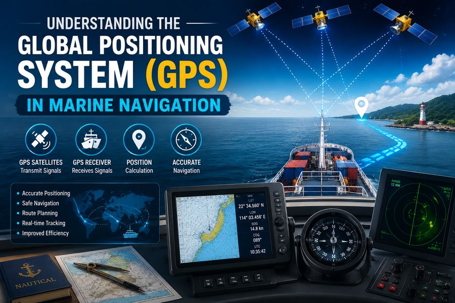
GPS allows ships and boats to determine their position almost anywhere on Earth by receiving signals from satellites orbiting high above the planet. Marine GPS systems can provide information such as latitude, longitude, speed, direction of travel, distance to a waypoint, and estimated arrival time.
When combined with electronic charts, radar, sonar, and other navigation systems, GPS becomes an extremely powerful tool for professional mariners and recreational boaters alike.
However, GPS is not perfect. Satellite signals can be blocked, interfered with, or manipulated, so safe navigation still requires multiple sources of information and good seamanship. ⚓🧭
🛰️ What Is GPS?
The Global Positioning System is a satellite-based navigation system that allows compatible receivers to calculate their location using radio signals transmitted from space.
A GPS receiver does not normally need to transmit a signal back to the satellites. Instead, it listens for precisely timed signals sent by multiple satellites.
Using those signals, the receiver calculates its position.
Marine GPS equipment may display:
- 📍 Latitude and longitude
- 🧭 Course over ground
- 🚤 Speed over ground
- 📏 Distance to destination
- ⏱️ Estimated time of arrival
- 🗺️ Waypoint information
- 🛣️ Planned route
- 📊 Track history
This information can significantly improve situational awareness while navigating at sea.
🌍 How Does GPS Work?
GPS relies on three major parts, often called segments:
- Space segment
- Control segment
- User segment
🛰️ 1. Space Segment
The space segment consists of satellites orbiting Earth.
These satellites continuously transmit navigation messages containing information about:
- Satellite position
- Precise time
- Orbital data
- System status
A marine GPS receiver attempts to receive signals from several satellites simultaneously.
🖥️ 2. Control Segment
Ground-based monitoring and control facilities track the satellites.
These stations help maintain accurate orbital and timing information.
Corrections and updated navigation data can be uploaded to the satellites as necessary.
🚢 3. User Segment
The user segment includes GPS receivers.
On a vessel, this may be:
- A dedicated marine GPS unit
- A chartplotter
- An integrated bridge system
- A handheld navigator
- A smartphone or tablet
- Navigation equipment connected to other onboard systems
The receiver processes satellite signals and calculates the vessel’s location.
📡 How Does a GPS Receiver Determine Position?
GPS positioning is based primarily on measuring the travel time of radio signals.
Radio waves travel at approximately the speed of light.
If the receiver knows:
- When a satellite transmitted a signal
- When the signal arrived
- The satellite’s position
it can estimate the distance between itself and the satellite.
The simplified relationship is:
Distance = Signal Travel Time × Speed of Light
The receiver repeats this calculation using several satellites.
It then determines where those distance measurements intersect.
This process is commonly described as trilateration.
🔢 Why Does GPS Need Multiple Satellites?
A single satellite cannot determine a vessel’s complete position.
With signals from multiple satellites, the receiver can solve for several unknown values.
In general, GPS receivers use at least four satellites to calculate:
- Latitude
- Longitude
- Altitude
- Receiver clock error
Marine vessels are mainly interested in horizontal position, but the receiver still benefits from additional satellite signals.
Modern receivers frequently track far more than four satellites.
The more useful satellites available, the better the receiver may be able to maintain accurate and reliable positioning.
⏱️ Why Is Accurate Time So Important?
GPS depends on extremely precise timing.
Satellites carry highly accurate atomic clocks.
Even a tiny timing error can create a large positioning error because radio signals travel so quickly.
For example, light travels approximately:
300,000 kilometers per second
A timing error of just one microsecond could correspond to roughly:
300 meters of distance error
GPS receivers therefore use satellite measurements to continuously correct their own internal clock calculations.
🌐 GPS Coordinates in Marine Navigation
Marine navigation commonly expresses position using latitude and longitude.
Latitude
Latitude measures position north or south of the equator.
It ranges from:
- 0° at the equator
- 90° north at the North Pole
- 90° south at the South Pole
Longitude
Longitude measures position east or west of the prime meridian.
It ranges up to:
- 180° east
- 180° west
A GPS receiver may display coordinates in several formats.
Mariners must ensure that the coordinate format matches the chart or navigation system being used.
🗺️ GPS and Electronic Charts
One of the most useful applications of GPS in marine navigation is integration with electronic charts.
A chartplotter combines GPS position information with a digital nautical chart.
The vessel’s position appears directly on the map. 🚢📍
This makes it easier to see the vessel in relation to:
- Coastlines
- Channels
- Buoys
- Harbors
- Rocks
- Shoals
- Navigation hazards
- Restricted areas
- Planned routes
Modern systems may update the vessel’s position continuously as it moves.
⚓ What Are Waypoints?
A waypoint is a stored geographic position.
A mariner may create waypoints for:
- Harbor entrances
- Navigation buoys
- Fishing locations
- Anchorages
- Route turning points
- Safe-water positions
GPS equipment can calculate the direction and distance from the vessel’s current position to a waypoint.
For example, the display might indicate:
Distance to waypoint: 6.4 nautical miles
Bearing to waypoint: 075°
This can help the crew navigate accurately toward the desired location.
🛣️ Routes and GPS Navigation
Multiple waypoints can be connected to create a route.
A route represents a planned sequence of positions the vessel intends to follow.
For example:
Departure harbor → Channel waypoint → Offshore waypoint → Destination harbor
The GPS or chartplotter can guide the vessel from one waypoint to the next.
It may calculate:
- Required course
- Remaining distance
- Estimated arrival time
- Cross-track error
However, a GPS route should never be followed blindly.
Charts, depth, weather, vessel draft, traffic, and local hazards must still be considered.
↔️ What Is Cross-Track Error?
Cross-track error, often abbreviated XTE, indicates how far a vessel has moved sideways from its intended route.
Imagine a planned straight line between two waypoints.
If wind, waves, or currents push the vessel away from that line, the GPS can calculate the perpendicular distance between the vessel and the intended track.
This helps the navigator identify route deviations.
A small cross-track error may be acceptable in open water, while even a modest deviation could be dangerous in a narrow channel.
🧭 Course Over Ground vs. Heading
One important concept in marine GPS navigation is the difference between course over ground and heading.
🚢 Heading
Heading is the direction the bow of the vessel is pointing.
A compass typically measures heading.
🛰️ Course Over Ground
Course over ground, or COG, is the actual direction the vessel is moving across Earth’s surface.
These values can be different.
For example, a boat may point north while a strong current pushes it northeast.
Its heading might be:
000°
while its course over ground might be:
025°
Understanding this difference is extremely important for safe navigation.
🚤 Speed Over Ground vs. Speed Through Water
GPS usually provides speed over ground, commonly abbreviated SOG.
This measures how quickly the vessel is moving relative to Earth’s surface.
A separate speed sensor may measure speed through the surrounding water.
Currents can cause these numbers to differ.
For example:
A vessel may move through the water at:
10 knots
while benefiting from a 2-knot current.
Its GPS may show approximately:
12 knots speed over ground
These measurements help navigators understand how currents affect vessel movement.
📏 How Accurate Is Marine GPS?
Modern GPS receivers can often provide position accuracy within several meters under good conditions.
Accuracy depends on factors including:
- Number of satellites visible
- Satellite geometry
- Atmospheric conditions
- Receiver quality
- Signal obstruction
- Interference
- Correction systems
For many marine applications, this level of accuracy is extremely useful.
However, a few meters can still be important near:
- Rocks
- Narrow channels
- Docks
- Shallow water
- Harbor entrances
Mariners should therefore avoid assuming that the GPS position is perfectly exact.
📡 Differential GPS and Correction Systems
GPS accuracy can be improved using correction systems.
Differential GPS, often called DGPS, uses information from known ground reference stations to estimate positioning errors.
Corrections can then be transmitted to compatible receivers.
Satellite-based augmentation systems can also provide correction information over large areas.
These systems may improve:
- Accuracy
- Integrity
- Reliability
High-precision positioning is particularly valuable for applications such as harbor operations, surveying, dredging, and offshore engineering.
🚢 GPS in Commercial Shipping
Large commercial ships rely heavily on satellite navigation.
GPS information may feed several onboard systems, including:
- Electronic chart systems
- Radar
- Automatic Identification System
- Autopilot
- Voyage data recorders
- Dynamic positioning systems
Integration allows multiple systems to use a common vessel position.
For example, radar targets may be compared with electronic chart information while the ship’s location is continuously updated by satellite navigation.
🧭 GPS and ECDIS
Large vessels often use an Electronic Chart Display and Information System, commonly called ECDIS.
ECDIS combines electronic nautical charts with real-time navigation information.
GPS position can be displayed directly on the chart.
This helps navigators monitor:
- Route progress
- Safety contours
- Hazard proximity
- Cross-track distance
- Waypoint approach
- Position history
ECDIS can greatly improve situational awareness, but trained officers still need to verify that the position and chart data are trustworthy.
📡 GPS and AIS
The Automatic Identification System, or AIS, allows vessels to exchange information with other ships and shore stations.
AIS messages may include:
- Vessel identity
- Position
- Speed
- Course
- Destination
- Navigation status
GPS or another satellite navigation source often provides the position and movement information used by AIS.
Nearby vessels can then appear on compatible displays.
AIS is valuable for collision awareness, especially in busy shipping areas.
However, it should not replace radar observation or visual lookout.
🛳️ GPS and Autopilot Systems
GPS can also provide navigation commands to an autopilot.
For example, the GPS system may calculate the desired course toward a waypoint.
The autopilot can then adjust the rudder to maintain that course.
This can reduce crew workload during long passages.
However, automated navigation requires careful monitoring.
Unexpected hazards, currents, equipment failure, or incorrect route data can make automatic steering dangerous if left unchecked.
⚙️ GPS in Dynamic Positioning
Some offshore vessels use dynamic positioning, or DP, to automatically maintain a precise position without anchoring.
These vessels may support:
- Offshore drilling
- Underwater construction
- Cable laying
- Research operations
- Diving operations
Dynamic positioning systems combine positioning data with information from:
- GPS
- Gyrocompasses
- Wind sensors
- Motion sensors
- Thruster systems
Computers automatically control propellers and thrusters to keep the vessel near the required location.
Because positioning is critical, high-end systems often use multiple independent sensors for redundancy.
🎣 GPS in Fishing
Fishing vessels and recreational anglers use GPS extensively.
Locations can be stored as waypoints for:
- Productive fishing grounds
- Reef structures
- Wrecks
- Safe channels
- Harbor entrances
GPS can also record tracks showing where a vessel has traveled.
When combined with sonar or fish-finding equipment, GPS can help crews return precisely to productive areas.
⛵ GPS for Recreational Boating
Small boats can benefit from GPS just as much as commercial ships.
Common uses include:
- Returning to a marina
- Navigating coastal waters
- Tracking speed
- Following routes
- Finding anchorages
- Recording previous tracks
Handheld marine GPS devices are useful as backups because they can operate independently of the vessel’s main electrical system.
🌫️ GPS in Poor Visibility
Fog, rain, darkness, and heavy weather can make visual navigation difficult.
GPS can continue providing position information even when shore features and navigation marks cannot be seen clearly.
This makes it extremely valuable during low visibility.
However, GPS does not directly detect other vessels, floating debris, or uncharted obstacles.
Radar and visual lookout remain important.
🌊 How Currents Affect Marine Navigation
Ocean currents can significantly alter the vessel’s actual path.
GPS helps reveal these effects by showing course and speed over ground.
For example, if a vessel is steering one direction but moving in another, the navigator can identify the influence of current.
This information is useful for calculating:
- Course corrections
- Arrival times
- Fuel consumption
- Efficient routing
⛽ GPS and Fuel Efficiency
Accurate positioning can help vessels follow more efficient routes.
Avoiding unnecessary course changes and excessive distance can reduce:
- Fuel consumption
- Voyage time
- Operating cost
- Emissions
Commercial navigation systems can combine GPS information with weather, current, and voyage planning data to optimize routes.
For large ships, even a small percentage improvement in fuel efficiency can produce substantial savings.
⚠️ Limitations of GPS in Marine Navigation
GPS is extremely useful, but it has vulnerabilities.
Understanding these limitations is essential.
🏔️ Signal Obstruction
GPS signals are weak by the time they reach Earth’s surface.
Large structures, cliffs, or onboard equipment can interfere with reception.
🌌 Atmospheric Effects
Signals passing through Earth’s atmosphere can experience small timing errors.
Modern receivers compensate for many of these effects.
🛰️ Poor Satellite Geometry
If visible satellites are positioned close together in the sky, positioning accuracy may decrease.
Widely distributed satellites generally provide better geometry.
⚡ Electronic Interference
Radio-frequency interference can disrupt satellite reception.
Marine electronics should therefore be installed carefully.
🚨 GPS Jamming
GPS jamming occurs when radio interference prevents a receiver from detecting legitimate satellite signals.
Because GPS signals arriving from space are relatively weak, even a nearby interference source can cause significant disruption.
Signs of jamming may include:
- Sudden loss of position
- Incorrect position warnings
- Multiple navigation systems failing simultaneously
- Loss of satellite tracking
Mariners operating in areas where interference is possible should be prepared to navigate without GPS.
🎭 GPS Spoofing
GPS spoofing is different from jamming.
Instead of preventing signals from being received, spoofing attempts to provide false navigation signals that cause a receiver to calculate an incorrect position.
This can be especially dangerous because the system may appear to be working normally.
Possible warning signs include:
- Position suddenly shifting
- GPS track conflicting with radar
- Speed or course becoming unrealistic
- Electronic position disagreeing with visual observations
For this reason, professional navigation depends on cross-checking independent sources.
🧭 Why Traditional Navigation Skills Still Matter
GPS has made navigation easier, but traditional skills remain essential.
Mariners should understand methods such as:
- Compass navigation
- Dead reckoning
- Visual bearings
- Radar navigation
- Chart work
- Celestial navigation where appropriate
If GPS becomes unavailable, crews must still know the vessel’s approximate position and safely continue navigation.
Technology should support navigational judgment, not replace it.
🗺️ What Is Dead Reckoning?
Dead reckoning estimates a vessel’s current position based on:
- Previous known position
- Course
- Speed
- Time traveled
For example, if a vessel travels at 10 knots for two hours in a constant direction, it would cover approximately:
10 × 2 = 20 nautical miles
Dead reckoning becomes less accurate over time because currents, wind, steering errors, and speed variation accumulate.
GPS provides frequent position updates that can correct these estimates.
🧲 GPS Does Not Replace the Compass
GPS can calculate the direction a vessel is moving, but when the vessel is stationary or moving very slowly, course-over-ground information may become unreliable.
A magnetic or gyrocompass provides heading independently.
This is another reason marine navigation systems use multiple sensors.
🔄 Redundancy in Marine Navigation
Professional marine navigation follows the principle of redundancy.
Instead of relying on one source, crews compare:
- GPS
- Radar
- Compass
- Visual observations
- Depth sounder
- AIS
- Electronic charts
- Paper or backup charting methods where applicable
If one system disagrees with the others, the navigator can investigate.
Redundancy is especially important during:
- Harbor approaches
- Narrow-channel navigation
- Severe weather
- Poor visibility
- Offshore operations
🌐 GPS and Other Satellite Navigation Systems
Although GPS is the best-known satellite navigation system, it is not the only one.
Other global or regional navigation satellite systems include systems operated by different countries and regions.
Modern marine receivers may support multiple satellite constellations simultaneously.
This broader concept is known as Global Navigation Satellite Systems, or GNSS.
Using multiple constellations can improve satellite availability and positioning reliability.
🧰 Important GPS Features for Mariners
When selecting a marine GPS or chartplotter, useful features may include:
- Waterproof construction
- Bright daylight-readable screen
- Reliable satellite reception
- Accurate nautical charts
- Route planning
- Waypoint storage
- Track recording
- AIS integration
- Radar integration
- Depth-sounder compatibility
- Backup power capability
The most advanced device is not automatically the best choice.
The equipment must match the vessel’s size, operating environment, and navigation requirements.
🛡️ Safe Use of GPS at Sea
Good practice includes:
- Verify GPS position against other navigation information.
- Check that the correct chart datum and coordinate settings are being used.
- Keep navigation charts updated.
- Monitor cross-track error.
- Maintain a backup positioning method.
- Avoid blindly following automatically generated routes.
- Check for hazards between waypoints.
- Watch for sudden or unrealistic position changes.
- Maintain proper lookout at all times.
The navigator remains responsible for safe vessel operation, even when automated systems are available. ⚓
🔮 The Future of GPS in Marine Navigation
Marine satellite navigation continues to improve.
Future systems are likely to combine:
- Multi-constellation GNSS
- Higher positioning accuracy
- Improved anti-jamming systems
- Inertial navigation
- Artificial intelligence
- Advanced electronic charts
- Autonomous vessel technology
Autonomous and remotely operated ships will require highly reliable positioning systems.
Rather than relying on GPS alone, future vessels may combine satellite navigation with radar, cameras, inertial sensors, and other technologies.
This is sometimes called sensor fusion.
If one source becomes unreliable, the vessel can compare it with others and continue navigating safely.
❓ Frequently Asked Questions About GPS in Marine Navigation
What does GPS do on a ship?
GPS provides the vessel’s geographic position and can also calculate speed over ground, course over ground, distance to waypoints, and estimated arrival time.
How many satellites are required for GPS?
A typical GPS receiver uses at least four satellites to calculate a full position and correct its internal timing error. Modern receivers generally track many more when available.
Is marine GPS always accurate?
No. GPS is highly accurate under good conditions but can be affected by satellite geometry, signal interference, atmospheric conditions, jamming, and equipment problems.
What is the difference between GPS and a chartplotter?
GPS determines position. A chartplotter combines position information with electronic nautical charts and navigation functions.
Can GPS replace radar?
No. GPS tells you where your vessel is, while radar detects surrounding objects such as ships and land features. The systems serve different purposes.
What is GPS spoofing?
GPS spoofing involves transmitting deceptive navigation signals that can cause a receiver to calculate an incorrect position.
Why should mariners have backup navigation methods?
Satellite signals and electronic equipment can fail. Backup methods help ensure safe navigation if GPS becomes unavailable.
🎯 Conclusion
The Global Positioning System has transformed marine navigation. 🛰️🌊 What once required extensive calculations, visual observations, and manual plotting can now be supported by continuous satellite-based position information.
GPS helps mariners determine where they are, how fast they are moving, what direction they are traveling, how far they are from their destination, and whether they are staying on their intended route.
When integrated with electronic charts, radar, AIS, autopilot systems, and dynamic positioning equipment, GPS becomes part of a sophisticated navigation network used by vessels of nearly every size.
However, satellite navigation should never be treated as infallible.
Jamming, spoofing, signal obstruction, equipment failure, and simple human error can all create dangerous situations. Safe navigation therefore requires mariners to compare GPS information with independent sources such as radar, compass readings, visual observations, depth information, and traditional navigation techniques.
The most important principle is simple:
GPS is an extremely powerful navigational aid, but safe marine navigation still depends on skilled people using multiple sources of information. ⚓🧭🛰️
As maritime technology advances toward increasingly automated and autonomous vessels, satellite navigation will remain a fundamental part of how ships understand their position on the world’s oceans.