
A vessel leaves port before dawn, with the shoreline fading behind it and open water ahead. For the bridge team, the question is deceptively simple: where are we, where are we going, and what may cross our path before we get there?
For most of maritime history, answering that question demanded patient observation, manual calculation, local knowledge, and a healthy respect for uncertainty. A cloud-covered sky, an unreliable compass, or an unfamiliar coast could turn a routine passage into a demanding navigational problem.
Modern ships can display position, charted hazards, traffic, weather information, machinery data, and route plans on connected screens. Yet the purpose of navigation has not changed. It remains the disciplined process of taking a vessel safely from one place to another while accounting for the sea, the ship, and the people around it.
Understanding how navigation evolved helps marine engineers, deck officers, and shore-side professionals see why today’s integrated bridge systems are powerful—but never self-sufficient.
🌊 Navigation Is More Than Finding a Position
Ship navigation is the practice of determining a vessel’s position, planning and monitoring its movement, and avoiding danger along the route. A position alone is not enough; a ship also needs a safe track, an understanding of its speed and motion, and awareness of other vessels.
The sea adds complexity. Wind, waves, current, tide, visibility, traffic density, draft restrictions, and equipment condition can all alter what is safe. Navigation is therefore both a technical and operational discipline.
🧭 The Earliest Tools: Coastlines, Landmarks, and Memory
Early mariners commonly navigated by keeping land in sight. Headlands, islands, river mouths, mountain profiles, and recognizable coastal features gave practical reference points.
This method, often called coastal or pilotage navigation, was effective where local knowledge was strong. Its weakness was obvious: once a vessel lost sight of land, or encountered darkness, fog, or unfamiliar waters, visual memory alone could not provide a reliable fix.
⭐ Celestial Observation Opened the Ocean
Celestial navigation allowed seafarers to estimate position from the observed altitude of the Sun, Moon, planets, or stars. The angle between a celestial body and the horizon, measured at a known time, can be converted into a line of position.
By combining two or more suitable observations, a navigator can derive a position fix. This made longer ocean passages more manageable because the sky offered reference points even far from land.
📐 Latitude Was Easier Than Longitude
Latitude describes distance north or south of the Equator. It can be estimated from the altitude of the Pole Star in the Northern Hemisphere or from the Sun’s meridian altitude, with appropriate corrections.
Longitude, east-west position, proved harder because it depends on accurate time. Since Earth rotates at a predictable rate, the difference between local time and the time at a known reference meridian indicates longitude. Without a dependable clock at sea, that calculation carried substantial error.
⏱️ Marine Chronometers Changed Ocean Passage Planning
The marine chronometer was a major practical advance because it could preserve a reference time with far better reliability than earlier shipboard clocks. A navigator could compare local noon with chronometer time and calculate longitude.
The chronometer did not remove the need for skill. Officers still needed accurate observations, corrections for instrument and atmospheric effects, and careful calculations. But it made systematic global navigation far more attainable.
🔭 Sextants and the Discipline of Observation
A sextant measures the angle between two visible objects, most commonly a celestial body and the horizon. Its mirrors allow the observer to bring the image of a star or the Sun down to the horizon line.
Good sextant work depends on a clear horizon, stable handling, exact timing, and correct adjustment for errors such as index error. The instrument rewards practiced technique rather than hurried use.
- Take several sights rather than relying on one reading.
- Record the exact time of each observation.
- Apply known corrections methodically.
- Compare the result with the vessel’s estimated position and other evidence.
🗺️ Dead Reckoning Filled the Gaps Between Fixes
Dead reckoning estimates present position from a known earlier position, course steered, speed, and elapsed time. It is not an observed position; it is a calculated prediction of where the ship should be.
Current, leeway, steering error, and inaccurate speed information cause dead-reckoning error to grow over time. Still, it remains a fundamental navigational habit: every modern position display should be judged against the vessel’s expected movement.
🌬️ Currents, Wind, and Leeway Complicate the Track
A ship’s heading is the direction its bow points. Its course over ground is the direction it actually travels over the seabed. These may differ when current or wind acts on the vessel.
Leeway is the sideways drift caused primarily by wind. Set and drift describe the direction and rate of current. A navigator must distinguish these effects because a vessel can appear to be steering correctly while being carried toward shallow water or a traffic separation boundary.
🧲 The Magnetic Compass Brought a Constant Reference
The magnetic compass gave mariners a direction reference independent of daylight and clear skies. It was transformative, but its north is magnetic north rather than true north.
Charts and route planning use true directions, so compass readings require correction. Variation is the difference between true and magnetic north, while deviation is error caused by the ship’s own magnetic influences. Both must be understood before a compass course can be trusted.
⚙️ Gyrocompasses Reduced Magnetic Limitations
A gyrocompass uses the behavior of a rapidly spinning rotor and Earth’s rotation to seek true north. Unlike a magnetic compass, it is not directly affected by magnetic variation or most onboard magnetic fields.
Gyrocompasses became especially valuable for steel ships and for systems needing a stable true-heading input, such as radar plotting and autopilots. They still require correct operation, maintenance, settling time, and awareness of possible errors during rapid maneuvering or at high latitudes.
📢 Sound Signals and Traditional Awareness
Before electronic surveillance, safe navigation depended heavily on visual lookout, sound signals, lead lines, and local seamanship. In restricted visibility, mariners used prescribed sound signals to communicate their presence and maneuvering status.
These practices remain relevant. Electronic equipment improves awareness, but it cannot replace a proper lookout or the ability to interpret what another vessel is actually doing.
📻 Radio Direction Finding Added Electronic Bearings
Radio direction finding allowed a ship to obtain a bearing to a transmitting shore station or beacon. Crossed bearings from two stations could provide a fix, while a single bearing could help confirm a coastal approach.
The system had limitations, including signal interference, propagation effects, and dependence on shore infrastructure. Even so, it marked an important transition: navigators could use invisible electronic signals as well as visible natural references.
📡 Radar Made the Surrounding Sea Visible
Radar transmits radio pulses and displays echoes returned from targets such as land, ships, buoys, and precipitation. It gives the bridge team a practical picture of nearby surroundings in darkness or reduced visibility.
Radar does not literally show a photographic image. Its usefulness depends on tuning, range selection, sea-clutter and rain-clutter controls, target interpretation, and correct alignment with heading information. A poorly adjusted radar can conceal small or weak targets.
🎯 ARPA Turned Echoes into Motion Information
Automatic Radar Plotting Aid, usually called ARPA, assists the navigator by tracking radar targets and calculating information such as closest point of approach (CPA) and time to closest point of approach (TCPA).
CPA and TCPA help identify collision risk, but they are estimates derived from data over time. Sudden course or speed changes, target swapping, weak echoes, and sensor errors can make the displayed prediction misleading. Officers must verify targets and continue visual and radar observation.
📻 AIS Improved Vessel Identification
The Automatic Identification System, or AIS, broadcasts selected vessel data such as identity, position, course, speed, heading, and voyage-related information. It can help a watchkeeper identify a nearby ship more quickly than radar alone.
AIS is valuable but not a collision-avoidance substitute. Data may be delayed, incorrectly entered, unavailable, or absent from vessels not transmitting. Radar detects echoes; AIS reports data. Using both provides a more complete picture than relying on either one alone.
🛰️ Satellite Navigation Transformed Position Fixing
Global navigation satellite systems provide position, velocity, and time information by measuring signals from satellites. GNSS is the broad term; GPS is one widely used satellite navigation system within that wider category.
For routine navigation, satellite positioning offers fast, continuous fixes with a level of convenience earlier generations could not have imagined. However, signal blockage, interference, receiver faults, poor antenna placement, and signal manipulation can affect reliability.
🧭 Position Integrity Matters as Much as Position Accuracy
A displayed position may look precise while still being wrong. The key question is not only “What position is shown?” but also “How confident are we that this position is valid?”
Good bridge practice compares GNSS information with independent evidence: radar ranges and bearings, visual marks, depth trends, gyro heading, expected progress along the route, and where appropriate, celestial or manual methods. This is known as cross-checking, and it is a core defense against single-source failure.
📜 Paper Charts Preserved a Physical Planning Record
For generations, paper nautical charts were the main reference for route planning and position plotting. They show depths, aids to navigation, dangers, traffic routes, reporting areas, and other information needed for safe passage.
Paper charts demand careful correction when official updates are issued. Their strengths include independence from software and clear spatial overview; their drawbacks include the workload of maintaining, plotting, and managing a large chart portfolio.
💻 ECDIS Brought Charts Into the Digital Bridge
The Electronic Chart Display and Information System, or ECDIS, displays official electronic navigational charts and can integrate position, heading, radar, AIS, route plans, and alarms. When correctly approved, configured, and operated, it can serve as a primary means of navigation under applicable regulatory arrangements.
Its central advantage is integration. A navigator can see the planned route against charted information and current vessel position, while the system can alert the user to selected hazards or route deviations.
🧩 ENC Data Is Not Just a Digital Picture
An Electronic Navigational Chart (ENC) is structured digital hydrographic data, not simply an image of a paper chart. Because chart features have attributes, ECDIS can query objects and apply safety settings.
For example, a system may distinguish a charted obstruction from a depth contour and assess it against a vessel’s configured safety parameters. That automation is useful only when the chart data is current and the settings reflect the vessel’s actual draft and operating margins.
⚠️ ECDIS Safety Settings Need Deliberate Thought
Safety contour, safety depth, shallow contour, and deep contour settings influence how hazards are highlighted and when alarms may occur. These values should be selected through the vessel’s procedures and passage-planning process, not copied casually from a previous voyage.
A setting that is too permissive can hide a relevant danger. One that is overly conservative may produce frequent alarms, increasing the risk that users become desensitized and dismiss meaningful alerts.
🛤️ Passage Planning Connects Every Navigation Era
The equipment has changed, but passage planning still follows a recognizable sequence: appraisal, planning, execution, and monitoring. The team gathers information, designs a safe route, conducts the voyage, and checks whether the vessel remains safely on plan.
- Appraisal: assess charts, notices, weather, tides, vessel limitations, port information, and hazards.
- Planning: define tracks, wheel-over points, no-go areas, safety margins, reporting requirements, and contingencies.
- Execution: brief the bridge team and apply the plan while responding to actual conditions.
- Monitoring: verify progress continuously using independent means.
🔗 The Integrated Bridge System as a Shared Information Network
An integrated bridge system connects equipment such as ECDIS, radar, gyrocompass, GNSS receivers, speed logs, echo sounders, AIS, autopilot, alarms, and sometimes machinery or weather interfaces. The aim is to make relevant information available coherently at the point of decision.
Integration can reduce repetitive manual entry and make inconsistencies easier to spot. It can also create common-mode risk: if multiple displays depend on the same faulty heading sensor or position source, several screens may agree on the same wrong answer.
🖥️ Sensor Fusion Helps, but It Can Also Conceal Errors
Sensor fusion combines data from multiple sensors to create a more useful operational picture. For instance, radar overlays on an electronic chart can help compare radar coastline returns with charted features.
That convenience can be deceptive if source data is misaligned. A heading error, incorrect datum configuration, or timing mismatch can shift overlays and make the display appear convincing while being inaccurate. Independent checks must remain possible and routine.
🤖 Autopilots and Track Control Change the Helmsman’s Role
An autopilot maintains a selected heading, while track-control functions can steer a vessel along a planned route by responding to cross-track error. These systems can reduce workload during suitable open-water conditions.
They do not remove responsibility for navigation. Operators must understand limits on turn performance, rudder response, weather effects, sensor validity, and mode changes. A common error is assuming that a system following a route is also making safe collision-avoidance decisions; it is not.
🚨 Alarm Management Is a Human-Factors Problem
Modern bridges can generate many alarms, warnings, and advisories. Some are urgent, some are operationally useful, and some may result from settings that do not match the situation.
Alarm fatigue occurs when frequent low-value alerts reduce attention to important ones. Effective management involves correct configuration, prompt investigation, clear procedures, and a bridge culture in which alarms are not merely silenced to restore quiet.
👥 Bridge Resource Management Keeps Technology Accountable
Bridge resource management applies teamwork principles to navigation. It emphasizes communication, task sharing, challenge-and-response behavior, clear handovers, and the willingness of team members to question an unsafe assumption.
A junior officer who notices a mismatch between radar and ECDIS should be able to raise it immediately. A master or officer of the watch should encourage that intervention, because many navigational failures begin as an unchallenged small discrepancy.
🌫️ Restricted Visibility Tests Both Equipment and Judgment
Fog, heavy rain, haze, and darkness expose the limits of every navigational method. Radar may be affected by clutter or weak targets; visual detection is reduced; AIS may not reveal every contact; and collision risk can develop quickly.
In these conditions, safe practice centers on a proper lookout, safe speed, effective radar use, systematic plotting or tracking, sound signals where required, and early decisions. The correct response is not to trust one display more intensely, but to strengthen the whole navigational process.
🔐 Cybersecurity Has Become a Navigation Concern
Connected bridge systems depend on software, networks, interfaces, user accounts, and update processes. This creates risks beyond traditional mechanical or electrical failure, including malware, unauthorized access, corrupted data, and poorly controlled removable media.
Cyber resilience is practical seamanship in a digital setting. It includes controlled software updates, access management, network segregation where designed, crew awareness, backup arrangements, and reporting unusual system behavior rather than improvising a fix.
🔄 Resilience Means Having a Way Back to Basics
A resilient bridge can continue navigating safely when a key system degrades or fails. This does not mean rejecting digital equipment; it means preparing for its loss.
- Maintain competence in manual radar use, visual bearings, and dead reckoning.
- Know the location and purpose of independent sensors and backup arrangements.
- Record enough information to reconstruct position and intentions after a failure.
- Practice changeover and contingency procedures before they are needed.
Celestial navigation is no longer the routine primary method on most commercial ships, but its underlying lesson remains valuable: navigation improves when position is supported by independent observation.
🛠️ What Marine Engineers Need to Understand
Marine engineers may not normally plan the route, but navigation depends on reliable power, cooling, sensors, networked equipment, emergency supplies, and machinery response. A bridge system is only as dependable as the supporting shipboard infrastructure.
Engine-room and bridge teams benefit from shared awareness during equipment limitations. A generator changeover, steering gear concern, loss of cooling, electrical disturbance, or planned maintenance can affect maneuverability and the availability of navigation systems at critical moments.
🎓 Training Must Combine Button Knowledge and Navigation Sense
Competence with menus, layers, alarm acknowledgements, and route-check functions is necessary, but it is not enough. Watchkeepers also need spatial awareness: a mental picture of the vessel’s location, movement, nearby hazards, and available sea room.
Training is strongest when it links system operation to realistic decisions. Instead of only asking which button enables an overlay, it should ask what the overlay confirms, what could make it wrong, and what independent evidence should be checked.
🌐 The Next Bridge Will Be More Connected, Not Less Human
Navigation systems are likely to gain richer data exchange, improved decision support, condition monitoring, and greater shore connectivity. Remote assistance and increasingly automated functions may change how information is managed during some voyages.
More connectivity does not eliminate the need for competent people on board. It raises the value of people who can recognize poor data, understand system boundaries, manage abnormal conditions, and make defensible decisions when automation cannot resolve ambiguity.
⚓ The Core Principle: Verify, Understand, and Act
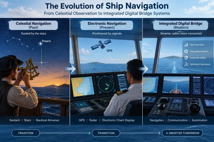
The journey from stars and sextants to ECDIS and integrated bridges is not a story of old methods becoming irrelevant. It is a story of navigators gaining more sources of information, faster calculations, and stronger tools for monitoring risk.
The enduring danger is overconfidence. Whether the input is a sextant sight, a magnetic compass, a radar echo, or a satellite position, it must be interpreted in context and checked against other evidence.
Safe navigation depends on informed human judgment supported by reliable systems, independent verification, and disciplined bridge teamwork.
The instruments have changed dramatically, but the navigator’s essential task remains constant: build an accurate picture of the situation, anticipate what may change, and keep the vessel safely clear of danger. 🚢 🧭 🌊