The geological evolution of coastal and marine environments in selected areas of the Tyrrhenian offshore (Cilento Promontory and Naples Bay, Campania, Italy) is highlighted through the construction of marine geological maps. The geological map n. 502 “Agropoli” (scale 1:50.000, Cilento Promontory) includes the coastal sector offshore the Cilento Promontory between the Agropoli and Agnone towns (southern Campania, Italy) and the surrounding marine areas. Sidescan sonar data have been calibrated by sea-bottom samples. The geological structures overlying the outcrops of acoustic basement have been investigated using subbottom Chirp profiles. The interpretation of Chirp data lends support for the reconstruction of the stratigraphic and structural setting of the Quaternary continental shelf successions and correlations to the outcrops of rocky acoustic basement in the Licosa Cape high. These areas result from the seaward prolongation of the stratigraphic and structural units, widely cropping out in the surrounding emerged sector of the Cilento Promontory(Southern Tyrrhenian Sea) [1; 2].
The techniques of sequence stratigraphy have been applied in the construction of geologic maps, according to the guidelines of marine geologic cartography [3; 4]. Local unconformities have been recognized at the top of pockets of coarse-grained materials, deposited in depressions or channels carving the top of the acoustic basement. The polycyclic nature of several unconformities is suggested by terraced surfaces localized at different water depths and recognized on seismic profiles. Several phases of emersion and erosion coupled to the development of marine terraces and progressive flooding occurred, as suggested by the seismic interpretation. The glacio-eustatic sea-level fluctuations during the Late Quaternary and the Pleistocenic uplift affecting the whole area represented the main control factors of marine-terraced surfaces [5; 6].
In the frame of the research convention for the realization of the geological map n. 502 “Agropoli,” the research projects co-financed in the CARG Project financed by the Region Campania, Sector of Soil Defence, Geothermy and Geotechnics are worth mentioning. These projects mainly include the research project GEOSED (financed by the Italian Ministry of the University and Scientific and Technologic Research) for geomorphologic and sedimentologic researches on continental shelf of southern Italy. The GEOSED project, which is complete, includes the geologic and morphologic survey at the scale 1:25.000 of selected areas of continental shelf of southern Italy (Capri Island, Punta Campanella, Ischia Island, Li Galli islands, and coastal belt surrounding the Naples and Pozzuoli towns). In the frame of this project, marine geophysical data have been recorded, mainly including multibeam bathymetry, around the Licosa Cape, allowing for the realization of a high-resolution digital elevation model (DEM) of the marine area surrounding the Licosa Cape [7].
The GEOSED acoustic project and swath bathymetric surveys carried out around the Licosa Cape and the Castellabate littoral (Salerno) have allowed to evaluate in detail the main environmental characters of the sea bottoms, furnishing a term of comparison for future observation in terms of environmental monitoring. These surveys have been realized in the frame of the GEOSED project (geomorphologic and sedimentologic study in selected areas of the continental shelf of southern Italy) finalized to the acquisition of geological knowledge on the sea bottom and on the first subbottom in relationship to the management of the coastal belt. The used instruments, in dotation to the R/V Thetis (Consiglio Nazionale delle Ricerche (CNR), Italy), included a lateral scanning probe (100–500 kHz digital Towfish – 2260NV) linked to a computerized station (ISIS Sonar Triton Elics) for sidescan sonar surveys and a multibeam system SEABAT 8111 Tx/Rx (Thales Inc.) with an operative frequency of 100 kHz. The performed surveys have allowed to individuate the morphological characteristics (terraces, vertical surfaces, grade of steepness, and drainage axes). The sea-bottom lineaments (ripples, current lineations, fishery lineations, and sea-bottom undulations), the occurrence of algal grasses (Posidonia oceanica), the processes of gravity instability, and the sedimentary dynamics at the sea bottom have allowed tracing the sediment distribution in terms of acoustic facies. The preliminary analysis of aerial photographs and official cartography has furnished the necessary hints for a geologic setting of adjacent emerged areas, allowing the establishment of land–sea correlations, a necessary element for a correct approach to the study and the management of coastal belts.
During the start-up phase of the research project of realization of a geologic map, a detailed collection of bibliographic data existing on the area of the Cilento Promontory and surrounding offshore has been carried out. The bibliographic research has contributed to delineate the state of the art of previous knowledge on the study of marine area and on the geologic knowledge on the adjacent emerged sectors (Cilento Promontory and Bulgheria Mt.). The collection of bibliographic data has evidenced that, while a good scientific knowledge exists on the emerged areas surrounding the geological map n. 502 “Agropoli,” including part of the Cilento Promontory, in particular the stratigraphic and structural aspects, due to the contribution of institutions and research settings operative in Campania from several tens of days (in particular some research groups pertaining to the Earth Science Department of the University of Naples “Federico II”), a poor knowledge exists on the recent geologic setting of the marine areas surrounding the Agropoli map, to whom concerns the sea bottom and subbottom geology. This knowledge is due to a few articles of marine geology carried out by the Istituto di Geologia Marina, CNR, Bologna (now ISMAR-CNR, Sezione di Geologia Marina di Bologna, Italy) and by the research group coordinated by Prof. T.S. Pescatore, Department of Earth Sciences, University of Naples “Federico II,” Italy.
Some papers will be recalled here in order to better focus on the research themes of this chapter [8- 13]. Marghany [8] has focused on a three-dimensional coastal deformation based on interferometry synthetic aperture radar (InSAR). Conventional InSAR procedures have been implemented to three repeat passes of ENVISAT (Environmental Satellite) ASAR (Advanced Synthetic Aperture Radar) data. The InSAR technique has allowed to produce detailed maps of earth’s surface deformation or digital terrain models through the implementation of the single-look complex synthetic aperture radar (SAR) images, which are received from two or more separate antennas. Moreover, the three-dimensional sorting reliability algorithm (3D-SRA) has been implemented by using the phase unwrapping technique. The aforementioned algorithm has been used to eliminate the phase decorrelation impact from the interferograms. The integration of the 3D-SRA algorithm with the phase unwrapping has produced accurate models of three-dimensional models of coastal deformation. Marghany [9] has presented a new approach to the 3D spit simulation using a differential synthetic aperture interferometry (DInSAR). The conventional procedures of this interferometry have been implemented to three repeat passes of RADARSAT-1 SAR fine mode data.
A new application, based on the fuzzy B-spline algorithm, has been implemented with the phase unwrapping technique. This analysis has shown that the performance of the DInSAR method using fuzzy B-spline is better than the DInSAR method. The integration of the fuzzy B-spline with the phase unwrapping has produced detailed three-dimensional geomorphological reconstructions. Marghany [10] has developed a new approach for the simulation of wave refraction patterns in airborne radar data. The analysis has shown that the wave refraction patterns can be simulated from AIRSAR and POLSAR data with a convergence and divergence spectra energy of 0.84 and 0.4 m2, respectively. The modification of conventional azimuth cutoff algorithm can be used to retrieve significant wave height in Cvv-band data under circumstances of wave transformation using first-order partial differential equations (PDEs). Marghany [11] has presented a three-dimensional model of coastal deformation using the sorting reliability algorithm of ENVISAT (Environmental Satellite) interferometric synthetic aperture radar.
The InSAR procedures have determined discontinuous interferogram patterns because of the high decorrelation. On the contrary, the 3D-sorting reliability algorithm has generated a 3D shoreline deformation with a bias of 0.08 m, lower than the ground measurements and the InSAR method. The 3D-SR algorithm has been used to solve the problem of decorrelation and has produced accurate 3D coastal deformation using ENVISAT (Environmental Satellite) ASAR (Advanced Synthetic Aperture Radar) data. Marghany (2014c) has studied the simulation of tsunami impact on the salinity of the sea surface in the coastal waters of Banda Aceh (Indonesia) using the least square algorithm from MODIS satellite data. The analysis has shown significant variations in the values of the SSS pro during and after the tsunami event. The maximum salinity of the seawaters observed after the tsunami event was 38 psu, higher than the salinities observed during and after the tsunami event. The 2004 tsunami had a significant impact on the sea surface salinity because of the high-sediment deposit concentrations, which added more salts and minerals to the coastal waters of Banda Aceh. The study of Marghany [13] was aimed at modeling the three-dimensional shoreline change rates using the differential interferometric synthetic aperture radar (DInSAR) technique. Nonetheless, the decorrelation plays a significant role to control the accuracy of three-dimensional object reconstruction using the aforementioned technique. This problem has been solved through the implementation of the multichannel MAP height-estimator algorithm within the ENVISAT ASAR data. The developed method has been applied to the example of the shoreline of Johor (Malaysia). The obtained results have shown that the accurate rate of shoreline change can be obtained with a root mean square error (RMSE) of 0.05 m using a multichannel height-estimator algorithm.
Geologic setting
THE EASTERN TYRRHENIAN MARGIN BETWEEN THE GULF OF SALERNO AND THE GULF OF POLICASTRO
The origin of the sedimentary basins and their subsidence along the Campania sector of the Eastern Tyrrhenian margin have been the subject of several studies based on field geological observations and on seismic and well data onshore and offshore [14- 39].The interpretation of multichannel seismic data pertaining to the “Zone E” (Ministry commercial seismics), together with the subsidence analysis carried out on lithostratigraphic data of deep wells, has shown notable differences in the long-term trends expected for the subsidence in the Salerno Basin [40], allowing for the recognition of late stages of compressional tectonics in the evolution of the sedimentary basin. This compressional tectonics, showing an age between the Late Pliocene and the Early Pleistocene, has involved the Campania offshore, between the Sorrento Peninsula and the Palinuro Cape. In correspondence with the opening of the Tyrrhenian basin, the extensional and strike-slip tectonics has been developed in this area since the Late Miocene, mainly after the compressional phases which have constructed the western sectors of the southern Apennines. The seismic profiles have demonstrated that the tectonic deformation was verified along a main system of listric normal faults, having an NE–SW trending, controlling the present-day setting of half-graben of the Salerno Basin. The compressional tectonic phase, ranging in age from Late Pliocene to Early Pleistocene, having an NNW–SSE trending for the maximum horizontal shortening, has provoked a reactivation of preexisting systems of normal faults having an NE–SW trending and has been responsible for processes of tectonic inversion in the Salerno Basin. This has provoked the deposition of sedimentary sequences characterized by shallowing upward at the top of the compressional structures during their formation, as well as the deformation and the flexural uplift for the subaerial exposure of the flanks of the basin (Mesozoic carbonate reliefs together with the basin filling of the Early Pleistocene) and the subsidence in the central sector of the basin.
According to the geologic interpretation of Sacchi et al. [40], the compression had a main role in enhancing the tectonic uplift and the subsidence; the tectonic phases recognized seaward may be tentatively related to the neotectonic evidence documented landward. After the Late Pleistocene, a new and generalized tectonic subsidence started in the Salerno Basin and around the southern rim of the Picentini Mountains, toward the inner part of the Sele Plain. The tectonic deformation and the erosional truncations in the Late Pleistocene sequences in the southern Salerno offshore, as well as the local tectonic uplift of the deposits of the latest Pleistocene several meters above the present-day sea level, suggest that the compressional events have been active since recent times. Hints of Late Neogene to Quaternary compressional tectonics in extensional domains have been already evidenced in other sites of the Mediterranean and North Atlantic regions; the evidence of these compressional phases is not directly related to thrust and belt deformation, which may be characterized by regional extension, may be related with main intraplate stresses.The continental shelf between the Gulf of Gaeta and the Cilento Promontory represents the seaward prolongation of the alluvial coastal plains bounding the Tyrrhenian sector of the Apenninic chain, which has been individuated after strong rates of tectonic subsidence in a regime of continental stretching and extension. These alluvial plains (Campania Plain, Sarno Plain, and Sele Plain) are bounded toward NE by the inner reliefs of the Apenninic chain, whose continuity is interrupted by structural highs having an NE–SW trending and by volcanic complexes (Phlegrean Fields and Somma-Vesuvius). The sedimentary filling consists of clastic marine and continental deposits, alternating, both in the Campania Plain and in the Sarno Plain, with abundant volcanic complexes. The age of this filling is mainly Pleistocene, although a precise dating of the first sequences overlying the acoustic basement is lacking [5].
The acoustic basement is represented by Meso-Cenozoic carbonates (Campania-Lucania platform) [1]and by deformed Cenozoic sequences and related flysch deposits (Cilento Flysch; Sicilide Units, Liguride Units) [41]. The southern boundary of the Campania Plain is represented by the volcanic district of the Phlegrean Fields, which has been active for the past 50 ky [42].The Tyrrhenian margin of Campania is characterized by the occurrence of marine areas undergoing a strong subsidence during the Plio-Quaternary and site of strong sedimentary fillings (“peri-Tyrrhenian basins”), such as the Terracina and Gaeta basins, the Capri basin, the Gulf of Naples, the Salerno Valley, and the Sapri and Paola basins. Under the Plio-Quaternary sedimentary cover, the continental margin of Campania is characterized by the occurrence of inner tectonic units of the Apenninic chain, resulting from the seaward elongment of the corresponding units cropping out in the coastal sectors of southern Apennines [1].Bartole [16] has formulated a regional synthesis on the tectonic setting of the Campania continental margin based on seismic and well data, where four main seismo-stratigraphic units have been recognized.
1. Upper post-orogenic sequence, composed of Early–Middle Pliocene sediments overlying a regional unconformity;
2. Lower post-orogenic sequence, ranging in age from Late Miocene to Early Pliocene;
3. Chaotic sequence, formed by strongly deformed Cenozoic sediments and related flysch deposits (Sicilide Units, Liguride Units, Frosinone Flysch, Cilento Flysch Auct.)
4. Deep carbonate sequence, forming the local acoustic basement, composed of Mesozoic carbonate platform units, widely cropping out onshore in the coastal sectors of central-southern Apennines.
According to the interpretation of Bartole et al. [17] and Bartole [16] in the Campania Tyrrhenian margin, both orogenic structures (Palmarola-Terracina overthrust, Zannone-Volturno overthrust, Salerno Valley, Sele line, Palinuro structure) directly related to the tectonic phases of orogenic transport of the Apenninic chain (Aquitanian–Langhian, Tortonian, Messinian, and Early Pliocene) [1; 43] and post-orogenic structures produced by Plio-Pleistocene extensional tectonics have been distinguished. Main orogenic structures, distinguished by these authors, in the offshore among the Gaeta and the Campania Plains are the Palmarola-Terracina overthrust, which is a deformational belt Messinian in age and is NE–SW trending, related to right strike-slip faulting during the Early Pliocene and the Zannone-Volturno overthrust, an N-verging thrust of the Middle Miocene having an E–W trending. The two described compressional trends seem to evidence a tectonic transport toward N–NE of tectonic units referred as Sicilide Units.The orogenic lineaments recognized in the offshore between the Gulf of Salerno and the Gulf of Policastro are the Salerno Valley, the Sele line, and the Palinuro structure. The Salerno Valley is represented by a deep depression having a WSW–ENE elongment, bounded northward by the normal faults downthrowing Mesozoic carbonates of the Sorrento Peninsula and filled with a Plio-Quaternary sequence up to 3300 m thickness (Mina 1 well); [44].
The neotectonic movements responsible for the uplift of southern Apennines start from the Early Pliocene and explicate through some extensional phases since the Middle–Late Pleistocene. The Quaternary neotectonics has played a fundamental role in constructing the present-day morphology of the Campania-Latium Tyrrhenian margin. This is demonstrated, for example, by the Quaternary marine and continental sedimentation of the Campania coastal plains, reaching a thickness of 3000 m and 1500 m in the Volturno Plain and the Sele Plain, respectively [43]. The structures having an Apenninic trending characterize the continental slope areas extending from the Pontine Islands (Ventotene slope) to the Cilento shoreline. The structural lineaments having a counter-Apenninic trending are widespread in the offshore between the Gulf of Salerno and the Sorrento Peninsula, where they have originated parallel structures having an NE–SW trending, giving rise to a horst-and-graben submarine topography. The half-graben sedimentary basins which characterize the Campania margin are interpreted, as a general rule, as the result of two extensional events, Pleistocene in age. The first event, which was developed during the Early Pleistocene along normal faults having an NW–SE trending, has allowed for the formation of coastal depressions of the Campania Plain, of the Sele Plain, and of the Volturno Plain. The second event, superimposed on an NE–SW trending fault system, at the boundary between the Early Pleistocene and the Middle Pleistocene, has produced the formation of the Naples Bay depression, producing half-graben-type asymmetrical structures, which characterize the whole Campania continental margin.
The offshore between the Sorrento Peninsula and the Cilento Promontory, hosting the structural depression of the Salerno Bay, is characterized by a continental shelf relatively wide and extended (up to 25 km) westward of the Cilento shoreline, with a thin sedimentary cover. Southward of the Sorrento Peninsula a reduced continental shelf and steep continental slopes occur, bounding the structural depression of the Salerno Basin. The individuation and the tectonic setting of the Salerno Basin have been mainly controlled by the Capri-Sorrento Peninsula master fault, showing a WSW–ENE trending (with an average throw of 1.5 km), bounding southward the structural high of the Sorrento Peninsula, where Mesozoic carbonate platform deposits widely crop out. Previous studies in the Salerno and Cilento offshore have mainly regarded the stratigraphy and the sedimentology of the Quaternary deposits [19; 45]. Minor attention has been paid to the structural setting of the area intensively explored by Italian oil companies [44; 20]. A Mesozoic carbonate platform unit, occurring in the subsurface of the Gulf of Salerno, has been recognized by deep exploration wells Mina 1, Milena 1, and Margherita mare 1 (VIDEPI Project; www.socgeol.it) [44] and is composed of limestones and dolomitic limestones, Cretaceous in age. The maximum thickness of the unit is in the order of 1300 m at the Milena 1 well. This unit is correlated with the Taburno-Picentini and Alburno-Cervati units, respectively, cropping out to the north and to the south of the fault zone known as the Sele line [1; 46; 41; 40; 21; 22]. This unit represents the carbonate acoustic basement on seismic profiles. A siliciclastic unit, Miocene in age, unconformably overlying the Meso-Cenozoic carbonate unit has been drilled by deep lithostratigraphic wells only in the Cilento offshore southward of the Sele line and has been correlated with the Liguride Units and the related foredeep deposits (Cilento Flysch), cropping out onshore in the Cilento Promontory [41].
The filling of the Salerno Basin starts (at the lithostratigraphic well Mina 1) [44] with the deposition of shales and marls ranging in age from the Late Tortonian and the Messinian, whose thickness is about 600 m, overlying a succession of marly shales and marls, with intercalations of sands and conglomerates, grading upward into marly shales with intercalations of thin sands (Pleistocene). The overall thickness of the Pleistocene filling of the Salerno Basin based on offshore well data ranges from 1500 to 2000 m. A regional unconformity, probably Messinian in age, related to a non-depositional/erosional hiatus (the Pliocene is completely lacking), characterizes the base of the Pleistocene sequences in the Cilento offshore (lithostratigraphic wells Milena 1 and Margherita mare 1)[44].
THE SALERNO BASIN: TECTONIC SETTING AND SEISMIC STRATIGRAPHY
The Salerno Basin (or Salerno Valley) is a Pleistocene half-graben, whose individuation and tectonic setting have been controlled by the normal fault Capri-Sorrento Peninsula, showing an average throw of about 1500 m [17; 16; 21; 22; 47]. This fault has controlled the origin of the Salerno canyon, showing active erosional processes and synsedimentary tectonics. The acoustic basement is composed of Mesozoic carbonate platform units (lithostratigraphic wells Mina 1, Milena 1, and Margherita mare 1) and overlying Miocene siliciclastic units related to the Liguride Units and foredeep deposits (Cilento Flysch), cropping out onshore in the Cilento Promontory [1; 46; 41]. The Salerno Basin shows an example of complex Quaternary filling of a tectonically controlled sedimentary basin, recording the interactions among the effects of eustatic sea-level oscillations and tectonic activity in the source region coupled with the tectonic deformation in the depositional area, lasting up to recent times. High sedimentary supply, combined with restrict sediment dispersal, has produced the deposition of a thick Quaternary succession, locally exceeding 3 km of thickness. The basin filling is composed of 1) marls and marly shales with intercalations of sands and conglomerates and 2) marly shales with intercalations of thin sands, Pleistocene in age. The average thickness of Pleistocene filling of the Gulf of Salerno based on offshore well data ranges between 1500 and 2000 m. In the Cilento offshore (Milena 1 and Margherita mare 1 wells), a regional unconformity, probably Messinian in age, related with a non-depositional and erosional hiatus (the Pliocene is completely lacking) characterizes the base of Pleistocene sequences.
Interesting evidence on the tectonic setting and the seismic stratigraphy of the Salerno Basin has been outlined by multichannel seismic profiles collected by IAMC-CNR of Naples, Italy. The line drawing of the seismic profile SAM7a (Cilento offshore) is represented in Fig. 1 [48] and discussed here. The seismic profile SAM7a runs from the Salerno offshore starting from the Amalfi town and shows a couple of conjugate listric normal faults, which is NNW–SSE dipping. These faults, indicative of strong releases of clastic multilayer, converge at several stratigraphic layers. In particular, some faults appear related to a master fault, NE–SW oriented (Capo D’Orso fault).
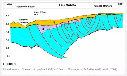
This seismic profile runs in the shallowest sector of the Salerno Valley, which, unlike the distal areas where the depositional processes prevail during the Late Quaternary, and appears to be struck by recent erosional processes, enabling the formation of the Salerno canyon. A main unconformity overlies the seismic sequences involved by extensional tectonics in correspondence to normal faults; it also marks the beginning of the deposition of relatively undeformed seismic sequences, forming a thick prograding wedge thickening from the platform margin toward the slope and toward the Salerno canyon. The prograding wedge has been supplied by the Sele river during the Late Quaternary.
The seismic profile SAM5 (Fig. 2) [48], showing a WNW–ESE trending (perpendicular to the Tyrrhenian shoreline), runs perpendicularly to the line SAM7 and has explored the central sector of the Salerno Basin where depositional processes, of basin filling, prevail. The tectonic setting, highlighted on the basis of geological interpretation of seismic profiles, is consistent with an extensional tectonic style, complicated by the occurrence of wide antiformal structures with ENE–WSW axes, involving the Pleistocene seismic sequences.
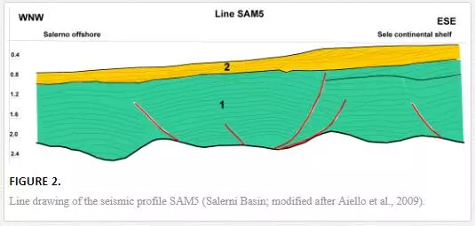
The seismic interpretation suggests that these structures are probably linked to rollover mechanisms, resulting from the envelopment of listric normal faults, shown by N–S-trending seismic profiles. A main tectonic unconformity marks the occurrence of a prograding wedge, relatively undeformed, which has been supplied by the Sele river mouth.
The stratigraphic architecture of the prograding wedge is well developed in continental shelf areas, where a stacking pattern of seismic sequences probably corresponding to a fourth-order glacio-eustatic cyclicity has been identified. The offlap breaks of the prograding clinoforms appear well preserved and indicate an aggradational component in the basal parasequences of the wedge and a more pronounced progradational component in the upper parasequences. A progressive seaward shifting of the parasequences in the continental shelf, up to the present-day rim of the continental shelf, located at about 135 m of water depth, indicates a normal coastal progradation controlled by high siliciclastic supplies of the Sele river. The Sele prograding wedge is bounded at its base by a regional unconformity, marked by the downlap of seismic reflectors and at its top by another unconformity, indicated by the erosional truncation of the prograding reflectors. In slope areas, the stratigraphic relationships of paraconformity among the fourth-order parasequences supplied by the Sele river are evident from seismic stratigraphy.
Based on the geologic interpretation of multichannel seismic profiles, the tectonic setting of the Salerno Basin is controlled by two low-angle normal faults, such as the Capri-Salerno fault, WSW–ENE trending and bounding southward the Sorrento Peninsula and the Capo D’Orso fault, having an NE–SW trending [48]. Several high-angle normal faults, parallel to the Capri-Salerno faults, have been singled out near the shoreline of the Sorrento Peninsula [49; 50]. Some normal faults having a minor entity, parallel to the Capri-Sorrento fault, are evident from seismic data analysis. They are both antithetic and synthetic to the Capo D’Orso normal fault. The sedimentary basins generated by lithospheric stretching are the sites of crustal extension as a consequence of passive rifting, assuming that the lithosphere has undergone extension with a uniform rate (i.e. uniform stretching) [51]. In a model of uniform stretching, the subsidence rates depend on the stretching rate and the lithospheric thickness [52]. The extension is often asymmetrical, since the faults propagate outward in a direction from the initial rifting of the upper continental crust. If the rifting process continues due to the critical values of stretching, a passive continental margin develops, characterized by the accumulation of thick sedimentary wedges deposited during the post-rifting phase. The patterns of faults in the rift systems were originally considered to bound a symmetrical arrangement of horst and graben [53].
Regional surveys of seismic reflection [54] suggest, however, that the rifts are characterized by a set of half-graben, with a polarity of the throw reversing in correspondence to strike-slip faults, involving the rift system. Estimates of extension rates in half-graben systems may be obtained based on subsidence curves, calculated by removing the effects of sedimentary loads. The activity of normal faults is responsible for local variation of subsidence rates or uplift rates, producing different depositional geometries in footwall and hanging wall blocks [55; 56]. The analysis of the seismic sequences deposited during the fault activity showing wedging depositional geometries offers the opportunity to investigate the tectonic movements along the fault.Structural styles of extensional basins are often characterized by listric normal faults, diminishing their inclination proceeding downward, becoming parallel and/or subparallel in the detachment zone, located next to the transitional zone from upper to lower lithosphere. Since the listric faults produce a differential rotation of the strata between the hanging wall and the footwall, a set of imbricated block faults should show rotations progressively steeper in the main throw direction. Small anthitetic faults of compensation related to listric geometries often remove the exceeding uplift and the stratigraphic gap occurring in the central block [54; 57]. The extension in the half-graben basins is often associated with a syntectonic sedimentation or wedging, indicating tectonic downthrowing contemporaneous to sedimentation. The listric normal faults may connect with low-angle master faults, forming main levels of detachment; in this case, the type of shear on the fault must change from upper to lower levels [58].
The Salerno Basin is a Pleistocenic half-graben originated from the Capri-Sorrento Peninsula master fault, showing a throw in the order of 1.5 km, and is filled by marine clastic and epicontinental deposits. Strong reflectors, inclined toward SSE with apparent angles of 10°–15°, appear on seismic profiles, indicating the occurrence of levels of detachment in the carbonate multilayer. The extension in the Salerno Basin is controlled by groups of listric normal faults, joining on low-angle detachment plans. Another preferential detachment level is located at the top of Miocene flysch terranes. Bathymetry and high-resolution seismics of the Salerno Valley [47] indicate that the depositional processes of infilling prevail in the continental shelf located eastward, while the western sector of the half-graben is the site of processes of erosion and sedimentation still active in a canyon (the Salerno canyon) deep from 600 to 1000 m. The occurrences of wedging geometries in the sedimentary successions, of tectonic unconformities, and hummocky reflectors and chaotic facies at several stratigraphic levels indicate a strong synsedimentary tectonics and a strong uplift of the surrounding emerged areas during the Pleistocene. Anticlinalic structures with ENE–WSW axes suggest two rollover mechanisms resulting from the envelopment of listric faults and tectonic inversion of the half-graben, according to an N–S compression or a transpression along the master fault Capri-Sorrento Peninsula. Extensional processes seem to be still active in the Salerno Basin, being responsible for the present-day topography of the sea bottom and the foreland uplift along rift shoulders (Sorrento Peninsula).
A seismo-stratigraphic and morpho-bathymetric analysis on the continental margin of southern Campania in the elongment Sorrento Peninsula-Capri island [47] has been carried out based on multibeam bathymetric data and high-resolution multichannel seismics recorded by IAMC-CNR (Istituto per l’Ambiente Marino Costiero – Consiglio Nazionale delle Ricerche) of Naples, Italy, onboard of the R/V Urania (National Research Council of Italy). The acquisition of geophysical data, carried out in water depths ranging between 100 and 1000 m and calibrated on the integrated interpretation of bathymetric and seismic data in deep-sea depositional systems, has allowed the recognition of main morpho-structures cropping out at the sea bottom in slope and bathyal plain sectors and their correlation with the main seismic sequences.
The geophysical data have furnished interesting evidence on deformation styles in the Salerno offshore, characterized by the occurrence of NNW–SSE-trending tectonic lineaments. The data have been recorded in an SEG-D format with a sample interval of 0.5 msec and a time window of 8 sec. The length of the seismic profile is about 15 km with a maximum coverage of 12 km for CDP. The processing of seismic reflection data has been divided into a preliminary phase, during which the editing and the immission of field geometry of data have been carried out, and into a phase of advanced processing, during which the noise removal and the sea-bottom multiples attenuation have been carried out. During the phase of advanced processing, the traces have been elaborated with different algorithms of two-dimensional filtering. The velocity analysis has allowed for the plot of a preliminary seismic section, on which it has been possible to individuate which were more adequate processes to apply to these types of data. A spiking and predictive deconvolution has been applied to seismic sections, coupled with a time-variant filtering. The Salerno Valley represents a half-graben sedimentary basin, whose individuation has been controlled during the Early Pleistocene by the master fault Capri-Sorrento, bordering the southern margin of the Sorrento Peninsula with vertical throws in the order of 1.5 km, downthrowing Meso-Cenozoic carbonates under the Gulf of Salerno with a step of normal faults.The geologic interpretation of the L6 seismic profile carried out according to seismo-stratigraphic criteria has allowed the individuation of an important unconformity, located between 1.7 and 1.8 sec (TWT; two way travel times), related with the top of the Meso-Cenozoic carbonate sequence, widely cropping out onshore in the structural high of the Sorrento Peninsula. The unconformity bounds upward the carbonate acoustic basement, which is strongly downthrown by normal faults and marks the base of Pleistocene filling of the Salerno Valley. The basin filling shows an average thickness of about 500 m. The strong synsedimentary tectonic activity, lasting up to the Late Pleistocene in correspondence to listric faults having an NNW–SSE trending, has controlled the triggering of submarine gravity instabilities, evident as chaotic acoustic facies interstratified in the stratigraphic succession.
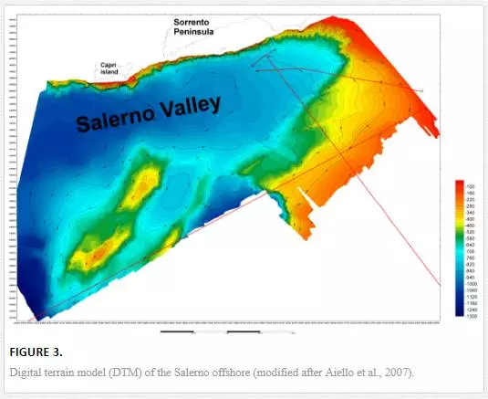
New geological evidence derives from a digital terrain model (DTM) of the Salerno offshore, whose interpretation has evidenced a dense network of channels, eroding the southern slope of the Sorrento Peninsula and representing the seaward elongment of the onshore torrents [47]. Among the morpho-structures occurring in the Salerno offshore, particularly relevant are the morpho-structural highs having an NNW–SSE trending identified on the marine DTM (Fig. 3) [47]. The two highs are separated by an intra-slope basin, now filled by sediments, which was the site during the Pleistocene of an area of sedimentary transport known as the Salerno canyon [21; 22]. The multibeam bathymetry has evidenced the occurrence of intra-slope basins, NNW–SSE trending, narrow, and elongated, which characterize the whole margin of the Latium-Campania. The recent age of the extensional tectonics, which has originated from the morpho-structural highs, has prevented the accumulation of thick sedimentary drapes over the two morpho-structural highs.
Previous geological studies
GENERAL SETTING
The Cilento Promontory represents a structural high, interposed between the coastal depressions of the Sele Plain–Gulf of Salerno and the Gulf of Policastro, whose relief reaches 1700 m high. These reliefs are composed of thick successions of siliciclastic and carbonate sequences (“Flysch del Cilento” Auct.), dipping landward in the main carbonate reliefs of Southern Apennines (“Alburno-Cervati Unit” Auct.). Quaternary normal faults define the borders of the structure of the Cilento Promontory. Apart from the carbonate structures of Palinuro Cape and Bulgheria Mount and several isolated outcrops, the reliefs of the Cilento Promontory are formed by terrigenous rocks, which were accumulated in deep basins in a time interval ranging between the Late Mesozoic and the Late Miocene. The oldest formation pertain to the Northern Calabrian Units [41], representing the highest stratigraphic structural unit of this sector of southern Apennines. In the Cilento area, this is represented by a formation ranging in age between the Malm and the Oligocene, composed of dark shales, marls, and marly limestones, showing a deformation grade lower than the overlying units (Cilento Flysch). The Cilento Flysch includes, proceeding upward, the Pollica, San Mauro, and Monte Sacro Formations, with a total thickness of 1500 m [41].The carbonate sequences exposed at the Palinuro Cape and in the carbonate massif of the Bulgheria Mount show paleo-sedimentary domains of slope–basin and show different facies with respect to the neritic limestones of carbonate platform cropping out in correspondence to the Alburno-Cervati massif [41]. During the Miocene, the Bulgheria Unit had been overthrust by the Northern Calabride Unit and the overlying Cilento Flysch. Nonetheless, the Bulgheria terranes are exposed in outcrop due to the next uplift of the Bulgheria-Palinuro Cape area (Late Miocene–Early Pliocene) and the consequent erosion of the terrigenous units [59]. The uplift of the Bulgheria Mount has provoked the northward folding of carbonate sequences and their thrusting over the Calabrian Units with a south-verging reverse fault, well exposed along the southern border of the Cilento [41].
In the western sector of the Cilento Promontory, several morphological depressions have been filled by alluvial deposits, whose origin must be attributed to structural elements with an NNE–SWW trending in the Alento Plain and NW–SE trending in the Santa Maria di Castellabate and San Marco plains. Brancaccio et al. [5] have attributed the formation of these depressions to the Late–Middle Pleistocene; they include transgressive–regressive cycles referred to as glacio-eustatic sea-level oscillations of isotopic stages 9, 7, and 5 [60; 61], downthrown a few tens of meters with respect to the original heights, between the end of the Middle Pleistocene and the beginning of the Late Pleistocene.The Cilento Promontory has been involved by a vertical uplift of 400 m during the Late Early Pleistocene and the Middle Pleistocene. Absolute estimates of the entity of tectonic uplift involving the Cilento Promontory have been obtained by the vertical distribution of Pleistocene marine terraces along the Cilento coasts. In the Northern Cilento, the oldest marine terraces (Middle Pleistocene) occur at maximum heights of 450 m, while the Emilian ones at heights of 350 m a.s.l. [62- 66].Morphological elements in the coastal areas relative to paleostands of the sea level during the Late Pleistocene (isotopic stages 5e and 5c) have evidenced a substantial tectonic stability of this tract of shoreline from the Tyrrhenian to recent times [67]. The absence of relevant vertical movements during the last thousands of years is well testified by the height of Versilian beach deposits. These deposits occur in coastal fluvial depressions, incised during previous glacial regression for more than 2 km inner to the shoreline.
The present-day coastal cliffs are incised in the sandy and silty successions of the Pollica Formation. Next to the Licosa Cape promontory, this formation composes a wide terrace of marine abrasion located at heights of 4–10 m a.s.l., extending from the San Marco plain to the Ogliastro Marina Bay.Northward of the carbonate blocks of Palinuro Cape and Bulgheria Mount, wide outcrops of a continental formation (Conglomerati di Centola) occur [68]. The lowest part of the formation, about 200 m thick, is represented by muddy, silty, and sandy deposits, with subordinate conglomeratic lenses, while the upper part is characterized by deltaic conglomerates with coarse-grained facies. The upper chronological boundary of the Centola conglomerates is furnished by Middle Pleistocene terraces of southern coastal slope of the Bulgheria Mount, which are strictly related to the terraces carving the Centola conglomerates at Palinuro.Several structural stratigraphic studies have been carried out on the onshore and offshore areas of Agropoli. The most relevant ones are discussed here.
STRATIGRAPHIC AND STRUCTURAL GEOLOGY
Scandone et al. [69] have recognized a sedimentary succession in the Bulgheria Mount ranging in age from Trias to Miocene, whose characteristics let us to consider it as a transitional succession to open-sea sediments. It is worth noting that the differentiation with the Cilento carbonate sequence and the Sapri Mounts becomes marked starting from the upper part of the Early Liassic. General conditions of uniformity reestablish from the Miocene, since the calcarenites with Miogypsinae of the Bulgheria Mount show characteristics very similar to the ones of the Sapri Mountains, which are instead transgressive above Senonian or Paleocene limestones. The main structural pattern involving the area is constituted of a reverse fault located to the eastern margin of the massif located between San Severino and Scario. The extensional faults are mainly Apenninic (NW–SE) in direction and are younger than the reverse fault.
Ietto et al. [70] have carried out one of the first structural and stratigraphic studies on the Cilento Flysch in the area located between the Alento Valley and the Licosa Cape. These authors have distinguished for the first time the three main formations of San Venere, Pollica, and San Mauro, which then become an integrant part of next geological literature, being classified as shaley flysch, arenaceous flysch, and conglomeratic-marly-arenaceous flysch, respectively.
Guida et al. [68] have carried out a detailed geomorphologic study on the basin of Mingardo river (Cilento), with a particular regard to landslide phenomena and landslide hazard of the study areas.
The applied themes of this research are based on geologic and morphologic surveys of the outcropping units and in particular on Pleistocene clastic deposits (Centola conglomerates). These deposits are composed of pebbles and blocks, highly rounded, immerged in an abundant sandy matrix. The source areas must be considered the morphological highs of the Cilento region, where the arenaceous and conglomeratic terms crop out. Several stratigraphic and structural units crop out in the basin, with terrigenous and carbonate successions. The morphologic trend is strictly related to the distribution of lithologies and geometries of geological bodies. In the geolithologic map, the lithostratigraphic sequences have been grouped into 13 lithological units with different lithotechnical characteristics. Moreover, the authors have elaborated some thematic maps relative to slope stability at the 1:10.000 and 1:25.000 scales. The morphological analysis elaborates on a morphometric map with five slope classes and a geomorphologic map, on which the most significant shapes of the relief are represented. Moreover, a detailed evaluation of the hazard to slide has been carried out, identifying the maximum hazard of slide deposits in a chaotic condition, while elevated conditions of instability individuate in terrigenous successions mainly composed of shales. Critelli and Le Pera [71] have carried out a lithostratigraphic study on the Pollica Formation, a Miocene turbidite succession more than 500 m thick, representing the lowest stratigraphic portion of the Cilento Group [72]. The lithostratigraphic, sedimentologic, and compositional analyses have allowed in dividing the Pollica Formation into two distinct members, probably separated by an angular unconformity. Member A (Arenarie di Cannicchio), characterized by thin turbidites pelitic-arenaceous in a distal environment, is strongly deformed and folded. Member B (Arenarie di Pollica), Burdigalian in age, represents a turbidite system evolving from lobe facies to channel facies. The petrography of the arenitic terms of both the members records a marked compositional evolution, passing from lithic arkoses (A petrofacies) for member A and the lowest part of member B toward siliciclastic sandstones (B petrofacies) and volcanic–siliciclastic sandstones
(C petrofacies).
This change of depositional and physiographic characters of the basin contrasts with the change of the detrital modes. The latter ones suggest a strong restructuration of the source areas. The A petrofacies should have metamorphic terranes as a fundamental source area, while the petrofacies B and C should mark areas from more complex sources. Metamorphic rocks are progressively substituted by plutonic fragments, while locally large volcanic supplies are coeval with the sedimentation and extrabasinal carbonate clasts that are concentrated in single depositional events occur. In the frame of a research program of systematic revision of the inner flysch of southern Apennines, Zuppetta et al. [73] have examined the terranes of the Albidona Formation in the area included between Sarconi and Trebisacce, which, at the Calabria-Lucania boundary, represents the highest formation of the Cilento Unit. In the study area these terranes unconformably overlie an ophiolitic nappe and the Crete Nere and Saraceno Formations, already deformed. This formation is characterized by arenaceous-pelitic facies, evolving upward towards arenaceous-conglomeratic facies. In this succession, slumpings and megaturbidites occur at several stratigraphic levels, testifying a strong tectonic activity. The age of the whole sampled succession obtained through the study of planktonic foraminifera ranges between the Late Oligocene and the Early Burdigalian. The obtained results give some consideration to the paleogeographic location of the sedimentary basin of the Albidona Formation, and precisely to its tectono-sedimentary evolution. Russo et al. [74] have carried out a stratigraphic revision of the Cilento Flysch (Pollica and San Mauro Formations). Datations carried out through planktonic foraminifera have allowed to date the Langhian as the lowest part of the Pollica sandstones and the Serravallian-Early Tortonian as the highest part of the succession, represented by the San Mauro Formation. These data have allowed in interpreting this succession as a deposit of a piggyback basin, whose outer flank is composed of a frontal ramp, located in correspondence with the paleogeographic domains corresponding to the Bulgheria-Verbicaro Unit.
Zuppetta and Mazzoli [75] have carried out a structural analysis of the Cilento Unit, including the turbiditic and siliciclastic terranes, Langhian-Tortonian in age (Pollica and San Mauro Formations), recording a succession of pre-tectonic and tectonic events. The pre-tectonic events have originated from synsedimentary structures of slumping and syndiagenetic structures (sedimentary dykes). Early tectonic events have produced minor reverse fault conjugates with respect to the stratification, while the most important ones have produced a regional folded structure having an SW vergence. Late tectonic events have produced a wide folding of the carbonate terranes of the Alburno-Cervati Unit. Based on the paleotectonic unit proposed here, the Cilento Flysch represents the deformed filling of a Middle Miocene foredeep. Critelli [76] has carried out a regional geological study in which the clastic successions of southern Apennines (among which the Cilento Flysch) have been put in relationship with the flexure of the lithosphere and the emplacement, in the nappes of the formation, of stratigraphic successions of the foreland basin of southern Apennines (Fig. 4) [76]. The clastic sediments of post-Oligocene sedimentary successions mainly derive from the allochtonous tectono-stratigraphic units of the northern Calabrian Arc. The stratigraphic and compositional relationships of clastic sediments of the sedimentary basins, interposed among the Calabrian microplate and the Adriatic microplate, implicate that the lithospheric flexuration of the Adriatic plate in conjunction with the tectonic accommodation of the Calabride crystalline nappes have been main control factors in the development of sedimentation of the foreland basin of Southern Apennines. The lithostatic load caused by the emplacement of the Calabrian nappes over the Adriatic plate, from Early Miocene to recent times, has provoked the flexural deformation of the Adriatic lithosphere, producing foredeep basins, forebulge areas, and back-bulge basins. The eastward migration of the lithosphere flexure happened through pulses as a response to the eastward transport of the Calabrian chain.
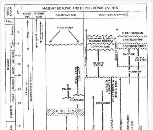
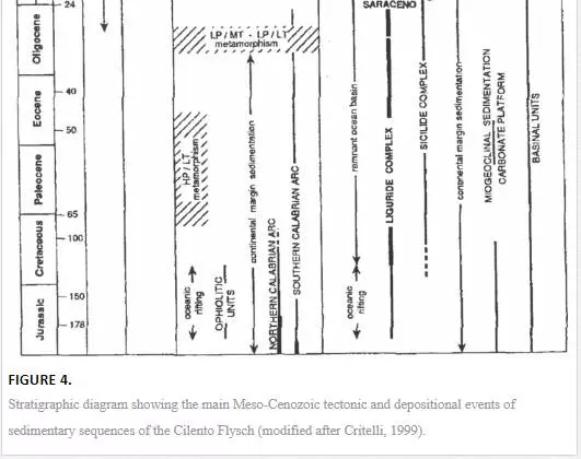
The stratigraphic sequences, key of the orogenic system of southern Italy, have been described by using new data and interpretations or through the reinterpretation of the data previously published (see the above mentioned corresponding figure) [76]. The denudation of the crustal terranes of the Calabrian Arc during the rapid uplift and erosion of the Middle–Late Oligocene since 10 my B.P. has produced abundant clastic sediments, which were accumulated in 1) an oceanic basin, Late Paleogenic in age (the Liguride Complex); 2) several Neogene foredeeps and depocenters in migration localized at the top of the foreland basins, migrating outward with the onset of the orogenic deformation; and 3) starting from the Late Tortonian, foreland basins and syntectonic back-arc foredeeps. In particular, the Cilento Group (Cilento Flysch) [70] ranging in age between the Langhian and the Tortonian [72; 74; 77], with thickness ranging from 1200 and 2000 m, unconformably overlies the Liguride Complex, which is in turn unconformably overlain by the Gorgoglione Formation (Late Tortonian) and the Monte Sacro, Oriolo, and Serra Manganile Formations (Fig. 5) [76].
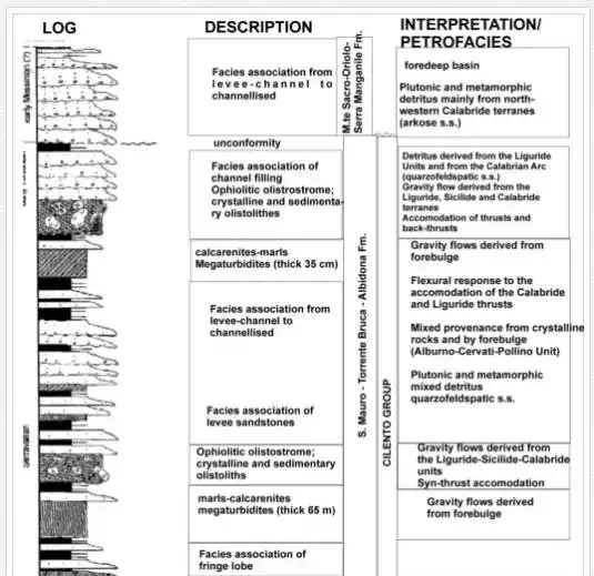
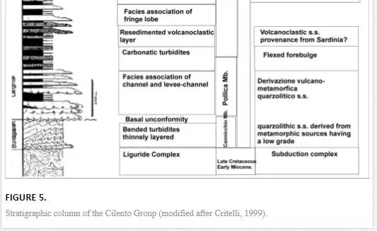
The Cilento Group consists of different turbiditic depositional systems [78]. More than the turbiditic siliciclastic strata, the Cilento Group includes several carbonate and clastic megastrata (ranging in thickness from a few tens of meters and several hundreds of meters) and coarse-grained volcaniclastic debris flows and turbidites. The sandstones of the Cilento Group are lithic, volcano lithic, and rich in feldspars [79]. In the upper Cilento Group, the carbonate and clastic megastrata and the olistostromes record the main tectonic events on the active orogenic belt. The olistostromes are siliciclastic and include blocks of Calabride terranes and Liguride Complex [70; 80- 83; 78]. The clasts derived from the Liguride Unit appear only in the middle and upper part of the Cilento Group, suggesting initial signals of the emersion of the Liguride Complex. Clear signals of emersion and erosion of the Liguride Complex are recorded by the Piaggine sandstones, ranging in age between the Serravallian and the Tortonian) [84- 86]. The Piaggine sandstones are derived from the detrital content of the Liguride Complex suggesting that, at the Serravallian-Tortonian boundary, the Liguride Complex was in a subaerial location [76].
SUBAQUEOUS GEOLOGY AND QUATERNARY GEOLOGY
Baggioni [87] has carried out a geomorphologic study of the Cilento coasts (southern Italy), evidencing that the present-day morphogenesis has been conditioned by the siliciclastic lithologies cropping out in the area, which can be easily eroded. This has provoked the formation of a platform of actual marine abrasion and has controlled the disappearance of the marine levels of the old Quaternary. Only a level attributed to Tyrrhenian 2 survived to the erosion involving the study area. The recent neotectonics is limited in entity, while the morphologic and stratigraphic evidence underlines the hypothesis of strong vertical movements during the Quaternary, conditioning the present-day trending of the shoreline. Some detailed morphologic sections on several localities of the Cilento shore have been produced. Baggioni [88] has carried out a study on the evolution of the carbonate slopes of the Bulgheria Mount, evidencing that the northern slopes show different geomorphological aspects with respect to the southern ones; while the first ones are characterized by a main reverse fault, which puts in contact the flysch with the limestones, with a slope higher than 50°, the southern slopes are characterized by a flight of step of normal faults in carbonate rocks with slopes less than 40°. Baggioni et al. [89] have carried out geomorphological studies in the surroundings of Marina di Camerota, where the occurrence of marine microfaunas has allowed differentiating the Late Pliocene terranes from the Calabrian to the post-Calabrian. Palynological analyses have allowed to put in relationship the evolution of the vegetation with that of the climate.
Ortolani et al. [90] have carried out a study of the Holocene geomorphologic evolution of the Velia coastal plain (Cilento) based on new archeological findings. New archeological studies carried out in the area of Velia (Cilento, Campania) have evidenced the occurrence, southward of Acropoli, of manufacts attributed to the VI century A.C. They are overlain by alluvial deposits including typical structures of liquefaction, interpreted as seismic. The archeological study and the stratigraphic analysis give further consideration to the recent evolution of the study area, particularly referring to the climatic events, which have conditioned several phases of aggradation and progradation of the old topographic surface and related paleo-shoreline of the alluvial coastal plain between the VI and IV century A.C. and since to recent epochs. Moreover, it can be evidenced that this alluvial period had an important influence on the Magna Grecia settlements, located in the alluvial coastal plains of southern Italy, and on social and economic developments of people. Antonioli et al. [59] have carried out a geologic and geomorphologic study finalized to the recognition of the traces of old stands of sea level and the effects which they, interacting with the tectonic activity, have produced on the Quaternary evolution of the landscape. The data have been collected both in emerged and submerged sector, up to a water depth of 50 m through ARA dives carried out both on the coastal cliff and in many karstic cavities occurring in the carbonate promontory. In an emerged coastal belt, a succession of seven orders of marine terraces at water depths ranging between 180 and 2 m a.s.l., incised both in the Mesozoic carbonate rocks and in the flysch terranes cropping out northward of Palinuro Cape. The first five orders of terraces are represented by surfaces of marine abrasion, while the sixth and the seventh orders are represented by abrasion platforms and notches incised along the carbonate cliffs of Palinuro Cape. The traces of the beach lines found between 12–14 and 7–8 m should be coeval, if not older, of the Last Interglacial.
Russo [91] has singled out a fossiliferous level, Tyrrhenian in age in the Cala Bianca Bay (Marina di Camerota, Salerno). The Cala Bianca coastal cliff is characterized by a succession of dolomitic rocks, Upper Triassic in age, passing upward the dolomitic limestones of Early Triassic. In many places of the bay, clastic deposits crop out, both coarse-grained and fine-grained, related to continental levels sometimes including paleolithic remnants. Shells of Mollusks of marine coastal environment sampled in a sandy conglomeratic deposit have been dated back through isoleucine epimerization. The obtained values have allowed an attribution of these deposits to isotopic stage 5 and of the isotopic curve of the oxygen (125 ky B.P.).Ascione and Romano [6] have carried out a detailed geomorphological study of the Bulgheria Mount through the identification of phases of uplift and subsidence, involving the area starting from the Early Pleistocene and the Middle Pleistocene. The end of vertical movements during the Late Pleistocene is demonstrated by the occurrence of Pleistocene paleobeaches, now uplifted at a water depth comparable with a highstand phase of 130 ky B.P., as recorded in stable areas of the Mediterranean region. The vertical movements of the area have been quantified through the study of marine terraces; the sum of these movements has produced a vertical uplift of the area of about 400 m starting from the Santernian, 150 of which were verified during the Middle Pleistocene. Along the Tyrrhenian coast of Southern Apenninic margin, other structural highs bounding the peri-Tyrrhenian depressions furnish evidence of subsidence episodes, which have interrupted the main trend of uplift of the area during the Quaternary. This, together with the distribution of Quaternary marine terraces and deposits, has evidenced that this sector of the Southern Tyrrhenian margin has undergone vertical movements of different entities.
MARINE GEOLOGY
The marine areas included in the geological map n. 502 “Agropoli” include a sector of continental shelf, developing with low gradients up to a water depth of 250 m. The topography of sea bottoms is particularly articulated and conditioned by the occurrence of an E–W-trending ridge along the 40°–14’ parallel. This element represents the seaward prolongation of the Licosa Cape morpho-structural high and constitutes the acoustic basement unconformably overlain by Pleistocene prograding units of continental shelf. The acoustic basement shows an irregular topography, characteristic of a morpho-continental evolution and an acoustic facies with chaotic reflections, typical of flysch terranes.
The Pleistocene deposits are organized in prograding units separated among them by several unconformities; in particular, two surfaces of marine ingressions, probably pre-Tyrrhenian and Versilian, have been recognized. The surface of marine ingression, Versilian in age, crops out at the sea bottom and reworks the subaerial erosional surface formed during the Last Pleniglacial. Palinsest deposits have been detected on this surface at a water depth of 160 m, composed of coarse-grained organogenic sands with fragments of Arctica islandica with a prograding internal structure interpreted as beach deposits related to the last sea-level lowstand, downthrown at greater water depths by phenomena of margin subsidence [92]. All the marine areas in the sectors surrounding the Cilento Promontory seem to be involved by a recent tectonics, characterized by sub-vertical faults with an NE–SW trending, bounding small basins on the continental shelf and upper slope. They are elongated parallel to the shoreline and represent depocentral areas in the Late Pleistocene, conditioning the present-day physiography of the continental shelf.The shelf break does not correspond, as it happens along the whole Tyrrhenian margin, to the last sea-level lowstand but is deeper, at 220 m. This underlines the importance of the structural elements in controlling the physiographic units in this sector.
Coppa et al. [45] have carried out a study of geomorphologic and faunistic elements of the Tyrrhenian continental margin between Punta Campanella and Punta degli Infreschi, characterized by three main morpho-structural units:
1. The continental shelf of the Gulf of Salerno, located in correspondence to the Sele basin. It is characterized by a gradient of 0.3°–0.8° and by a gradual shelf break, characterized by a thick Holocene sedimentation, underlain by the Wurmian erosional truncation, cutting older sediments.
2. The Cilento continental shelf located in correspondence to the structural high of the Cilento Promontory; this shows a variable slope, between 0.3° and 0.8° and its rim, located at 220 m of water depth, is abrupt. This is characterized by a scarce or absent Holocene sedimentation and by a wide diffusion. of relict morphologies. The continental shelf of the whole study sector is characterized by the abundance of microfossils and rests of plants.
3. Slopes and basins: the slope, with a gradient of 6°, is crossed by channels merging in basins; along this slope submarine slides are frequent.
Ferraro et al. [92] have carried out a study on the continental shelf between Licosa Cape and Palinuro Cape through subbottom and sparker profiles and sea bottom and subbottom samples in order to reconstruct the geological evolution of the continental shelf during the Late Pleistocene–Holocene. In its northern sector, the continental shelf is characterized by an offlap succession, which determines a seaward progradation of 10 km. Prograding units have been individuated, resulting progressively younger from land to sea. These sedimentary bodies refer to the general sea-level lowstand of the Late Pleistocene (isotopic stages 4, 3, and 2); this regression has happened in the frame of a fourth-order eustatic cycle. This area is characterized by normal faults, having an Apenninic trending, active since the beginning of the Late Pleistocene. These faults bound basin parallel to the shoreline, located both in platform and in slope.
The evolution of the continental shelf during the Late Pleistocene–Holocene can be schematized through the deposition of prograding units of the Late Pleistocene, referred to as isotopic stages 5, 4, and 3 [61], and then through the deposition, over a well-individuated ravinement surface, of sedimentary bodies characterized by middle-grained sands passing to silty shales, overlain by shales including a pumiceous level related to the A.D. 79 eruption of Vesuvius. These shales have been deposited during transgressive and highstand phases of the sea level, and they represent a thin drape over the erosional surface. With the end of isotopic stage 5a, the sea level results in constant lowering since isotopic stage 2, when it occurs at a water depth of 120 m in the Mediterranean [93]. During this phase of forced regression of the sea level[94] a prograding wedge deposits, produced by several minor units in offlap, progressively more recent from land to sea. The outer beach is correlated with the phase of lowstand of isotopic stage 2. The acoustic basement cropping out at the sea bottom should stay in a subaerial environment from isotopic stage 4.
Trincardi and Field [95] have presented an interpretation of the stratigraphic architecture of the prograding deposits offshore the Licosa Cape promontory. The prograding wedges of outer shelf and shelf break have been deposited over an erosional surface located in continental shelf and at the shelf break during the last phase of eustatic sea-level lowstand. During the next phase of sea level rise, the erosion linked to the shoreline shifting provokes the formation of a wide ravinement surface, recognized starting from the isobaths of 120 m landward, which provokes the partial erosion of the forced regression prograding wedge. The thickest of them has been preserved. In fact, thick prograding wedges in continuity of sedimentation have been observed only at the platform margin, while on the continental shelf, thin morphological relics have been preserved, mainly in correspondence to intra-platform depressions or morphological steps. Trincardi and Field [96] have carried out a detailed study of a wide submarine slide, involving the lowstand prograding deposits located westward to the Licosa Cape, based on the analysis of seismic profiles. The area of detachment is characterized by a wide mobilization surface located at its base, showing the deformation of the sediments above it in situ and which coincides with the sea bottom with a main downlap surface. The section involved by the slide is less than 20 m thick and has a local extension, but the deformation on the basal mobilization surface extends out of the slide area. Directly seaward with respect to the slide slope are the stratified muds, which do not show any evidence of deformation or movement. A part of the mobilized sediments has traveled toward the basin alongslope and then has accumulated to the base of a ridge parallel to the slope. The Licosa slide follows a main pulse of coastal sedimentation along the lowstand shoreline. On many continental margins, the eustatic sea-level lowstand is considered as a main cause of sliding of poorly consolidated sediments deposited during previous highstand conditions. The Licosa slide confirms the role of control, also if indirect, played by the eustatic sea level fall on the formation of submarine slides. When the sea level lowers and reaches its lowstand position, the fluvial channels reach their maximum location of efficiency and a coastal clastic wedge is rapidly emplaced with relatively high gradients at the shelf margin.
Results
MORPHO-BATHYMETRY OF THE AGROPOLI CONTINENTAL SHELF
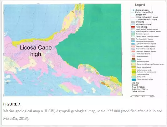
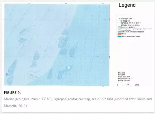
The morpho-bathymetry of the Agropoli continental shelf, strongly controlled by onshore geology and geomorphology, has been studied through the construction of four geological maps, herein shown (Figs. 6, 7, 8 and 9).
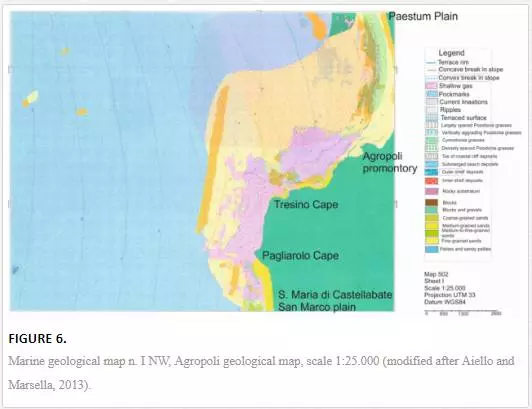
The map n. I NW (scale 1:25.000) shows a continental shelf dipping with low gradients up to water depths of 95 m (Fig. 6). Its northeastern extremity, including the farthest southern sector of the Paestum Plain, is regarded as little ramps up to water depths of 35 m. Next to the Agropoli promontory, the convex isobaths up to 25 m are conditioned by the trending of the rocky shoreline and the outcrops of acoustic basement. The rocky promontory between the Tresino Cape and the Pagliarolo Cape (Fig. 6) controls the physiography of the submerged area. The isobaths are convex in correspondence to the two promontories up to 35 m of water depth shaping the trend of high coastlines. The physiography of the continental shelf is strongly conditioned by the geomorphologic setting of the surrounding emerged area; up to a water depth of 40 m the isobaths are concave and close, showing a high gradient of the continental shelf.
The map n. II SW (scale 1:25.000) is typified by the physiographic unit of the Licosa Cape high (Fig. 7), represented by an E–W trending ridge. The isobaths show an articulated E–W trending. The isobath of 15 m bounds a wide area showing remnants of terraced surfaces localized at several water depths. The southern sector of the structural high is characterized by pronounced concavities of the isobaths representing slide scars incised by drainage axes.
The map n. III SE (scale 1:25.000) is portrayed by the main physiographic unit of the Licosa Cape morpho-structural high (Fig. 8). Three main morpho-structural highs of the acoustic basement occur to the northwest. The N–S first high strikes at water depths of 120–145 m; the second E–W appears at water depths of 120–140 m; the third one, showing an elongated NNW–SSE
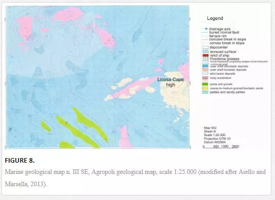
trending, extends from 85 to 115 m of water depth. Several bathymetric highs, showing an elongated shape and an NW–SE trending, are localized at water depths of 140–145 m. They are interpreted as relict morphologies corresponding to the last regressive phase and are represented by prograding sedimentary wedges. These sedimentary wedges signify portions of submerged beaches connected to fifth-order eustatic cycles, overlying the upper part of a wide Pleistocene prograding succession.
The map n. IV NE (scale 1:25.000) covers the continental shelf at water depths of 105–185 m (Fig. 9). Several convexities in correspondence to the isobaths of 135, 145, and 155 m probably correspond to remnants of terraced surfaces. The geological interpretation of seismic data has evidenced the outcrops at the sea bottom of a wide prograding succession dated to the Late Pleistocene and well evident on seismic profiles.
GEOLOGICAL UNITS
The main geological units mapped in the geological map n. 502 Agropoli are described herein (Figs. 6–9). The Cenozoic substratum is composed of Cenozoic siliciclastic rocks, genetically related to the Cilento Flysch. The unit crops out in the inner shelf, particularly offshore the Licosa Cape morpho-structural high and is terraced at its top by polycyclic erosional surfaces and covered by wide beds of marine phanerogams. The littoral environment is characterized by the deposits of submerged beach and of toe of coastal cliff, incised in the arenaceous-silty successions of the Cilento Flysch. The deposits of submerged beach are composed of gravels, sandy gravels, and coarse-grained sands with rounded to sub-rounded pebbles in a medium- to fine-grained sandy matrix; by coarse- to medium-grained sands, from rounded to sub-rounded, with pebbles and blocks, by medium- to fine-grained litho-bioclastic sands.The deposits of toe of coastal cliff consist of siliciclastic heterometric blocks.The inner shelf environment is characterized by innershelf deposits and bioclastic deposits. The inner shelf deposits consist of coarse-grained litho-bioclastic sands, middle-to fine- grained litho-bioclastic sands, and fine-grained pelitic sands.
The bioclastic deposits are made up of heterometric gravels, gravel sands, and bioclastic sands in a pelitic matrix. They represent the base of wide beds of marine phanerogams and overlie the top of outcrops of Cenozoic substratumThe outer shelf environment is typified by clastic deposits and bioclastic deposits. The clastic deposits are distinguished by middle-fine grained sands localized at the top of wide outcrops of Cenozoic substratum, by pelites and sandy pelites. The bioclastic deposits are composed of bioclastic calcareous sands in a pelitic matrix, organized as sedimentary drapes located at the top of outcrops of Cenozoic substratum or of Late Pleistocene relic deposits (Figs. 6–9).The lowstand system tract (LST) is distinguished by coarse-grained organogenic sands, grading upward into the middle-grained sands and pelitic drapes. They are relict littoral deposits organized as coastal prisms overlying the shelf margin progradations and representing portions of submerged beaches related to the last sea-level lowstand related to isotopic stage 2.The LST deposits form NW–SE-trending coastal dunes, occurring in the southwestern sector of the area, at water depths ranging between 140 and 145 m (Figs. 6–9).The Pleistocene relict marine units are represented by coarse- to fine-grained marine deposits, probably composed of well-sorted sands and gravels with bioclastic fragments and by medium-fine grained sands, with a pelitic coverage having a variable thickness but less than 2 m. They are localized in the NW and SW sectors of the Agropoli continental shelf and represent relics of beach and continental shelf environment interpreted as the remnants of older beach systems, related to isotopic stages 4 and 3 (Figs. 6–9).
Rocky units of the substratum
Cenozoic substratum
The Cenozoic substratum is composed of the siliciclastic rocks of the Cilento Flysch [2; 41; 77]. It crops out at the sea bottom next to the Licosa Cape morpho-structural high. Its top is marked by a polycyclic erosional surface involved by marine terraces. Wide grasses of marine phanerogams occur atthe top of the Licosa high up to a water depth of 30 m (Figs. 6–9).
Quaternary marine deposits
Littoral environmentSubmerged beach deposits
The submerged beach deposits include gravels, sandy gravels, and coarse-grained sands, with rounded to sub-rounded pebbles in a middle-to fine-grained sandy matrix, coarse-to-middle-grained sands, from rounded to sub-rounded, with gravels, pebbles, and blocks.
Toe of coastal cliff deposits
The toe of coastal cliff deposits include both siliciclastic heterometric blocks, from metric to decametric and siliciclastic heterometric gravels, from centimetric to metric.
Inner shelf environment Inner shelf deposits
The inner shelf deposits consist of litho-bioclastic coarse-grained sands, from well-sorted to poorly sorted, medium- to fine-grained litho-bioclastic sands, and fine-grained pelitic sands. The sandy fraction is composed of bioclastic fragments. Sandy ridges parallel to the shoreline have been interpreted on sidescan sonar profiles and reported on geological maps. Current lineaments parallel to the shoreline and perpendicular to the isobaths have also been identified.
Bioclastic deposits
The bioclastic deposits are made up of heterometric gravels, gravelly sands, and bioclastic sands, sometimes in a pelitic matrix. They are located at the top of outcrops of the acoustic basement.
Outer shelf environment Outer shelf deposits
The outer shelf deposits are made up of medium- to fine-grained sands with lithoclasts and bioclasts and abundant rhyzomes of marine phanerogams, pelites and sandy pelites, rich in small Gastropods, Vermetids, and small mollusks. Current lineaments have been recognized based on sidescan sonar profiles.
Bioclastic deposits
The bioclastic deposits are made up of calcareous sands in an abundant pelitic matrix, overlying the top of outcrops of acoustic basement, correlated with the Cilento Flysch in the western Licosa structural high or at the top of palimpsest deposits.
Lowstand system tract
The LST deposits are composed of coarse-grained organogenic sands including abundant shell fragments and fragments of mollusks (Arctica islandica, cold host of the Pleistocene), fragments of Echinids and Bryozoans, grading upward to medium-grained sands and pelitic covers having a variable thickness, but less than 2 m. They form coastal prisms overlying the shelf margin progradations and represent portions of submerged beach linked to the last sea-level lowstand [60; 61]. The coastal dunes have an NW–SE trending and occur in the southwestern sector of the area at 140–145 m of water depth. Their age is Late Pleistocene–Holocene.
Pleistocene relict marine units
The Pleistocene relict marine units are made up of coarse- to-fine-grained marine deposits, of well-sorted sands and gravels with bioclastic fragments and of medium- to fine-grained sands with a pelitic coverage having a variable thickness, but less than 2 m. They are located in the NW and SW sectors of the study area and represent palimpsests of beach and continental shelf environments.The Pleistocene marine units, overlying the LST deposits, stand for the remnants of older beach systems, correlated to isotopic stages 4 and 3 [60; 61].
SEISMO-STRATIGRAPHIC INTERPRETATION
The seismo-stratigraphic interpretation of strictly spaced grid of subbottom Chirp profiles, located on the Campania continental shelf among the Solofrone river mouth and the Agnone town, has been carried out.The seismic grid of study sections is located at water depths ranging between 10 and 150 m. Seismo-stratigraphic units separated by unconformities and/or paraconformities have been distinguished through the criteria of seismic stratigraphy [97; 98].
The acoustic basement has been mapped through the geological interpretation of Chirp profiles. It crops out at the sea bottom offshore the Licosa Cape, having an extension wider than the one previously singled out by maps reported in geological literature on the area [45; 92]. The study area, located between the Solofrone river mouth and the Agnone town, is distinguished in three sectors, characterized by different line trending and line spacing (Fig. 10).
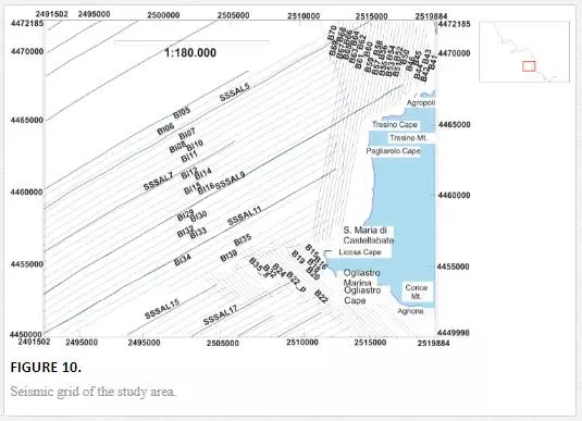
A first grid of seismic sections has been recorded on the inner shelf bounded northward by the Solofrone river mouth and southward by the Licosa Cape (Fig. 10). It is NNE–SSW oriented, parallel to the 50 m isobath and located at water depths of 10–60 m, with a line spacing of 250 m.A second grid is located on the inner shelf bounded northward by the Licosa Cape and southward by the Agnone town (Fig. 10). It is NW–SE oriented, perpendicular to the 50 m isobath and located at water depths of 10–60 m, with a line spacing of 250 m.A third set of NE–SW-oriented perpendicular sections covers the continental shelf bounded northward by the Solofrone river mouth and southward by the Agnone town, at water depths of 40–160 m. The line spacing is about 500 m.
Seismo-stratigraphic analysis of significant seismic sections, respectively, located in each of the abovementioned seismic grids, has been carried out. One main aim was the mapping of the rocky outcrops of the acoustic basement, while another aim was the mapping of marine terraces carving the rocky substratum. The measurement of the depth of marine terraces and their tentative correlation with the corresponding episodes of sea-level lowstand during the Late Quaternary have also been carried out [37].The seismic profiles B51 and B52 and corresponding geologic interpretation are reported in Fig. 11. The seismic line B51, about 6-km long and located at water depths of 12–20 m, has recorded a stratigraphic succession about 65-m thick (100 msec TWT), an excellent stratigraphic record for the Chirp profiles.
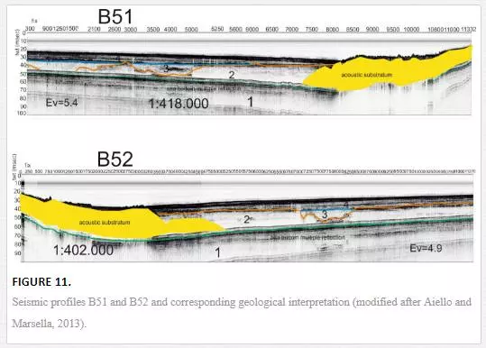
The top of the acoustic basement (S unit on seismic profiles) is incised by marine terraces at water depths ranging between 18 and 21 m.The first seismo-stratigraphic unit (Unit 1) is characterized by parallel seismic reflectors and shows an average thickness of 38 m (44 msec TWT). The unit is composed of marine sediments and bounded at its top by a paraconformity (Fig. 11).The second seismo-stratigraphic unit (Unit 2) shows an acoustically transparent seismic facies and a wedge-shaped external geometry; its top is bounded by an erosional unconformity. According to the geological interpretation, the unit should be composed of coarse-grained sands, forming the filling of channels (Fig. 11).The third seismo-stratigraphic unit (Unit 3) is characterized by discontinuous reflectors with high amplitude, alternating with acoustically transparent intervals and showing an average thickness of about 17 m (about 20 msec TWT).
Shallow gas pockets widely occur on seismic profiles and are in course of study with detail.The seismic line B52, about 6 km long and located at shallow water depths of 16.5–19 m, has shown a stratigraphic architecture similar to that of the seismic line B51 (Fig. 11).The first seismo-stratigraphic unit (Unit 1) is characterized by parallel seismic reflectors and shows an average thickness of 33 m (38 msec TWT). It is coeval with the acoustic basement (S unit; Fig. 11).The second seismo-stratigraphic unit (Unit 2) is characterized by an acoustically transparent seismic facies and by a wedge-shaped external geometry, filling wide paleo-channels.
The third seismo-stratigraphic unit (Unit 3; Fig. 11) is characterized by an acoustic facies with discontinuous reflectors having a high amplitude, alternating to acoustically transparent intervals and showing an average thickness of 17 m (about 20 msec TWT). The unit is probably composed of coarse-grained sediments. Shallow gas pockets have been identified on the seismic profile and are in course of study through a detailed analysis.
The B15 seismic line, NW–SE trending, located at water depths of 5–42 m, has crossed wide outcrops of acoustic basement offshore the Licosa Cape (Cilento Promontory). The top of the acoustic basement represents a terraced surface having a low gradient; marine terraces have been identified as occurring at water depths of 31, 19, and 5 m (Fig. 12).
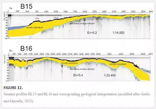
The B16 seismic line (Fig. 12), located at water depths of 12 and 47 m, has shown wide outcrops of rocky units of the acoustic basement. The stratigraphic architecture observed on seismic section is similar to the one recognized on the seismic section B15. The top of the acoustic basement is carved by marine terraces, occurring at water depths of 21, 14, and 11 m (Fig. 12). The BL05 seismic profile is located at water depths between 112.5 and 42 m (Fig. 13). It has crossed about 82 m of sediment (97 msec TWT; Fig. 13). Nearshore, the S unit crops out at the sea bottom, delineating a wide terraced surface, degrading seaward with low gradients. At the margin of this surface, the S unit is downthrown under the recent sedimentary cover. The S unit is then uplifted forming a structural high extending for almost 1.4 km (Fig. 13).
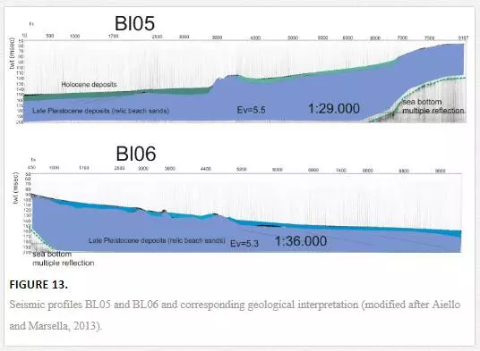
The first seismo-stratigraphic (Unit 1) shows an average thickness of about 50 m (60 msec TWT). It overlies the acoustic basement and is limited at its top by an unconformity (BA reflector), characterized by the onlap on the morpho-structural high of the S unit (Fig. 13).Lowstand deposits, characterized by prograding reflectors truncated upward by an erosional surface, have been interpreted (Fig. 13).The second seismic sequence (Unit 2), having a wedge-shaped external geometry, is characterized by pockets of coarse-grained marine sediments, representing the filling of channels.Marine terraces have been identified at 63 and 85 m of water depth (Fig. 13).The BL06 seismic line, having a length of about 4 km, is located at water depths of 120 m. It has shown a stratigraphic architecture similar to the ones in the BL05 seismic line (Fig. 13).
Conclusions
The geological evolution of coastal and marine environments offshore the Cilento Promontory (submerged beach, inner shelf, outer shelf, lowstand system tract, Pleistocene relict marine units, and rocky units of the substratum) has been discussed through the identification of corresponding deposits and their cartographic representation. The seismic stratigraphy of the Agropoli continental shelf (southern Campania) has been highlighted through the geological interpretation of a densely spaced grid of Chirp seismic profiles [37].The geological interpretation of Chirp profiles located in the morpho-structural high of the Licosa Cape has been largely documented in the acoustic basement (S unit), cropping out at the sea bottom near shore and dipping seaward below the Quaternary marine deposits, forming the recent sedimentary cover. Remnants of terraced surfaces located at several water depths have supported the morpho-evolution of the acoustic basement during the Late Quaternary.


